You are here: Home > Network List > CA - Catalan Seismic Network Stations List
> Station CGAR Garraf > Earthquake Result Viewer
CGAR Garraf - Earthquake Result Viewer
| Earthquake location: |
Central Mexico |
| Earthquake latitude/longitude: |
18.6/-98.5 |
| Earthquake time(UTC): |
2017/09/19 (262) 18:14:38 GMT |
| Earthquake Depth: |
51 km |
| Earthquake Magnitude: |
7.1 Mww |
| Earthquake Catalog/Contributor: |
NEIC PDE/us |
|
| Network: |
CA Catalan Seismic Network |
| Station: |
CGAR Garraf |
| Lat/Lon: |
41.29 N/1.91 E |
| Elevation: |
584 m |
|
| Distance: |
85.5 deg |
| Az: |
48.026 deg |
| Baz: |
290.616 deg |
| Ray Param: |
0.044645485 |
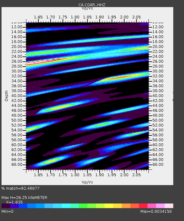
| Estimated Moho Depth: |
26.25 km |
| Estimated Crust Vp/Vs: |
1.63 |
| Assumed Crust Vp: |
6.391 km/s |
| Estimated Crust Vs: |
3.909 km/s |
| Estimated Crust Poisson's Ratio: |
0.20 |
|
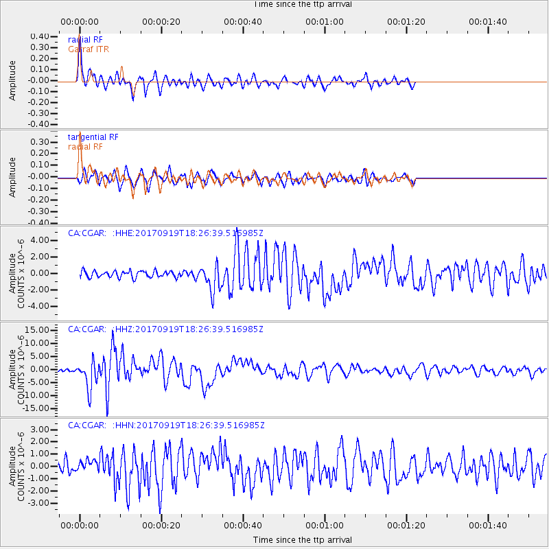
| Radial Match: |
92.49877 % |
| Radial Bump: |
400 |
| Transverse Match: |
81.00534 % |
| Transverse Bump: |
400 |
| SOD ConfigId: |
13570011 |
| Insert Time: |
2019-04-28 19:40:26.035 +0000 |
| GWidth: |
2.5 |
| Max Bumps: |
400 |
| Tol: |
0.001 |
|
Signal To Noise
| Channel | StoN | STA | LTA |
| CA:CGAR: :HHZ:20170919T18:26:39.516985Z | 13.083055 | 5.310068E-6 | 4.0587372E-7 |
| CA:CGAR: :HHN:20170919T18:26:39.516985Z | 1.148891 | 4.6716417E-7 | 4.0662187E-7 |
| CA:CGAR: :HHE:20170919T18:26:39.516985Z | 4.339589 | 1.6629137E-6 | 3.831961E-7 |
| Arrivals |
| Ps | 2.7 SECOND |
| PpPs | 11 SECOND |
| PsPs/PpSs | 13 SECOND |


