You are here: Home > Network List > TA - USArray Transportable Network (new EarthScope stations) Stations List
> Station LAVA Lava Cap Winery, Placerville, CA, USA > Earthquake Result Viewer
LAVA Lava Cap Winery, Placerville, CA, USA - Earthquake Result Viewer
| Earthquake location: |
New Britain Region, P.N.G. |
| Earthquake latitude/longitude: |
-5.5/151.8 |
| Earthquake time(UTC): |
2005/09/29 (272) 18:51:14 GMT |
| Earthquake Depth: |
25 km |
| Earthquake Magnitude: |
5.6 MB, 5.1 MS, 5.7 MW |
| Earthquake Catalog/Contributor: |
WHDF/NEIC |
|
| Network: |
TA USArray Transportable Network (new EarthScope stations) |
| Station: |
LAVA Lava Cap Winery, Placerville, CA, USA |
| Lat/Lon: |
38.76 N/120.74 W |
| Elevation: |
828 m |
|
| Distance: |
91.4 deg |
| Az: |
51.384 deg |
| Baz: |
264.161 deg |
| Ray Param: |
0.041601736 |
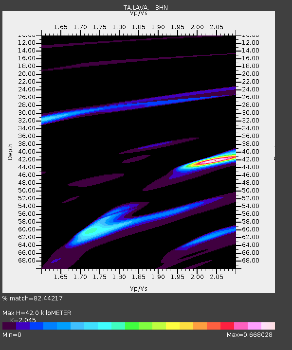
| Estimated Moho Depth: |
42.0 km |
| Estimated Crust Vp/Vs: |
2.05 |
| Assumed Crust Vp: |
6.597 km/s |
| Estimated Crust Vs: |
3.226 km/s |
| Estimated Crust Poisson's Ratio: |
0.34 |
|
| Radial Match: |
82.44217 % |
| Radial Bump: |
389 |
| Transverse Match: |
38.927742 % |
| Transverse Bump: |
341 |
| SOD ConfigId: |
132717 |
| Insert Time: |
2010-03-06 03:51:10.611 +0000 |
| GWidth: |
2.5 |
| Max Bumps: |
400 |
| Tol: |
0.001 |
|
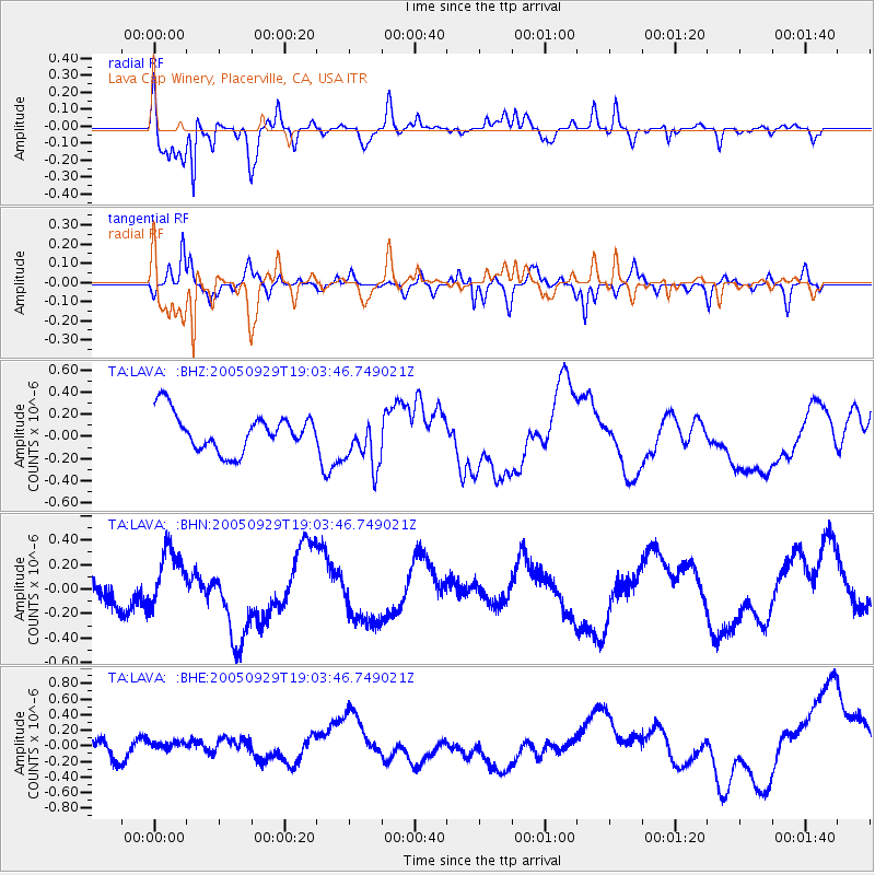
Signal To Noise
| Channel | StoN | STA | LTA |
| TA:LAVA: :BHN:20050929T19:03:46.749021Z | 1.2837331 | 2.4240816E-7 | 1.8883064E-7 |
| TA:LAVA: :BHE:20050929T19:03:46.749021Z | 0.60252684 | 6.8234776E-8 | 1.13247694E-7 |
| TA:LAVA: :BHZ:20050929T19:03:46.749021Z | 1.404106 | 2.3830306E-7 | 1.6971872E-7 |
| Arrivals |
| Ps | 6.8 SECOND |
| PpPs | 19 SECOND |
| PsPs/PpSs | 26 SECOND |


