You are here: Home > Network List > GS - US Geological Survey Networks Stations List
> Station KAN10 Keim Farm, Anthony, KS, USA > Earthquake Result Viewer
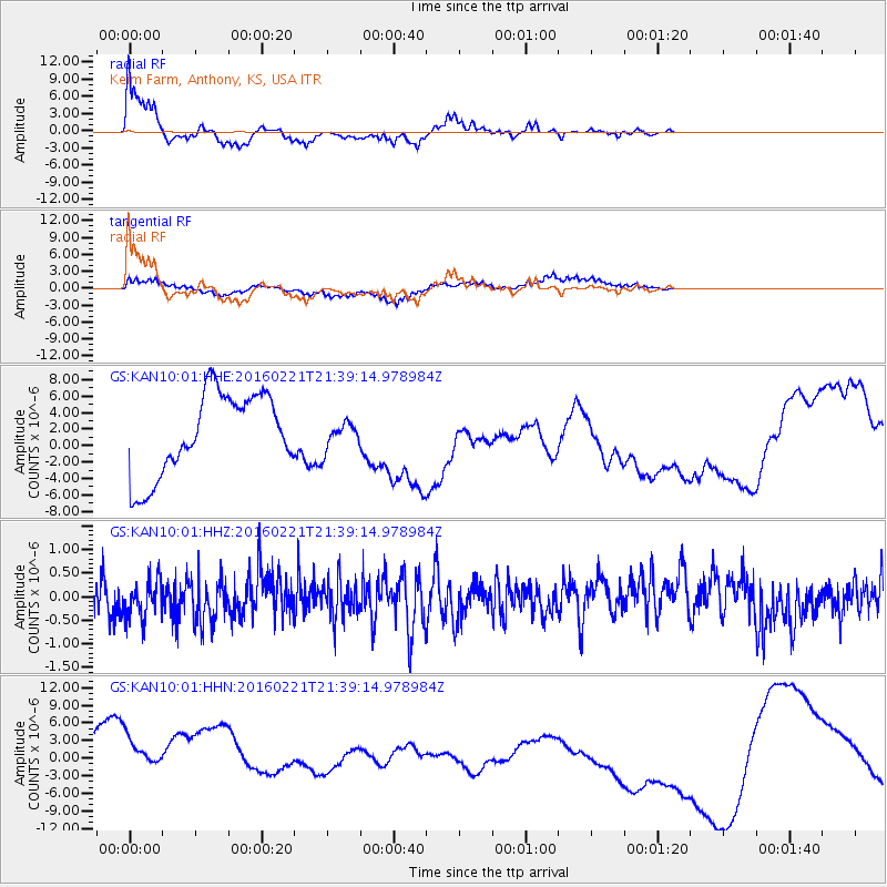
KAN10 Keim Farm, Anthony, KS, USA - Earthquake Result Viewer
*The percent match for this event was below the threshold and hence no stack was calculated.
| Earthquake location: |
Volcano Islands, Japan Region |
| Earthquake latitude/longitude: |
23.6/144.3 |
| Earthquake time(UTC): |
2016/02/21 (052) 21:26:23 GMT |
| Earthquake Depth: |
30 km |
| Earthquake Magnitude: |
5.6 MB |
| Earthquake Catalog/Contributor: |
NEIC PDE/NEIC COMCAT |
|
| Network: |
GS US Geological Survey Networks |
| Station: |
KAN10 Keim Farm, Anthony, KS, USA |
| Lat/Lon: |
37.12 N/98.10 W |
| Elevation: |
417 m |
|
| Distance: |
95.8 deg |
| Az: |
45.393 deg |
| Baz: |
305.199 deg |
| Ray Param: |
$rayparam |
*The percent match for this event was below the threshold and hence was not used in the summary stack. |
|
| Radial Match: |
72.24324 % |
| Radial Bump: |
378 |
| Transverse Match: |
55.898544 % |
| Transverse Bump: |
340 |
| SOD ConfigId: |
1427151 |
| Insert Time: |
2016-03-06 22:02:04.902 +0000 |
| GWidth: |
2.5 |
| Max Bumps: |
400 |
| Tol: |
0.001 |
|
Signal To Noise
| Channel | StoN | STA | LTA |
| GS:KAN10:01:HHZ:20160221T21:39:14.978984Z | 1.0612037 | 4.150095E-7 | 3.9107428E-7 |
| GS:KAN10:01:HHN:20160221T21:39:14.978984Z | 2.2889287 | 8.302628E-6 | 3.6272984E-6 |
| GS:KAN10:01:HHE:20160221T21:39:14.978984Z | 0.3313284 | 1.6486449E-6 | 4.9758637E-6 |
| Arrivals |
| Ps | |
| PpPs | |
| PsPs/PpSs | |


