You are here: Home > Network List > TA - USArray Transportable Network (new EarthScope stations) Stations List
> Station LAVA Lava Cap Winery, Placerville, CA, USA > Earthquake Result Viewer
LAVA Lava Cap Winery, Placerville, CA, USA - Earthquake Result Viewer
| Earthquake location: |
Peru-Ecuador Border Region |
| Earthquake latitude/longitude: |
-3.3/-81.0 |
| Earthquake time(UTC): |
2005/05/21 (141) 05:11:35 GMT |
| Earthquake Depth: |
40 km |
| Earthquake Magnitude: |
5.9 MB, 5.9 MS, 6.4 MW, 6.3 MW |
| Earthquake Catalog/Contributor: |
WHDF/NEIC |
|
| Network: |
TA USArray Transportable Network (new EarthScope stations) |
| Station: |
LAVA Lava Cap Winery, Placerville, CA, USA |
| Lat/Lon: |
38.76 N/120.74 W |
| Elevation: |
828 m |
|
| Distance: |
55.6 deg |
| Az: |
322.713 deg |
| Baz: |
129.326 deg |
| Ray Param: |
0.06459193 |
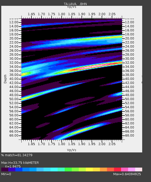
| Estimated Moho Depth: |
33.75 km |
| Estimated Crust Vp/Vs: |
1.95 |
| Assumed Crust Vp: |
6.597 km/s |
| Estimated Crust Vs: |
3.388 km/s |
| Estimated Crust Poisson's Ratio: |
0.32 |
|
| Radial Match: |
81.34279 % |
| Radial Bump: |
400 |
| Transverse Match: |
63.176914 % |
| Transverse Bump: |
400 |
| SOD ConfigId: |
132717 |
| Insert Time: |
2010-03-06 03:51:22.753 +0000 |
| GWidth: |
2.5 |
| Max Bumps: |
400 |
| Tol: |
0.001 |
|

Signal To Noise
| Channel | StoN | STA | LTA |
| TA:LAVA: :BHN:20050521T05:20:36.624009Z | 1.2479595 | 2.016489E-7 | 1.6158289E-7 |
| TA:LAVA: :BHE:20050521T05:20:36.624009Z | 1.1166661 | 1.5467145E-7 | 1.3851181E-7 |
| TA:LAVA: :BHZ:20050521T05:20:36.624009Z | 1.1147221 | 3.116783E-7 | 2.7960178E-7 |
| Arrivals |
| Ps | 5.1 SECOND |
| PpPs | 14 SECOND |
| PsPs/PpSs | 19 SECOND |


