You are here: Home > Network List > CN - Canadian National Seismograph Network Stations List
> Station A21 St-Andre, QC, CA > Earthquake Result Viewer
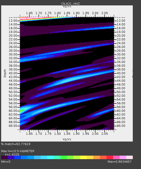
A21 St-Andre, QC, CA - Earthquake Result Viewer
| Earthquake location: |
Central Mexico |
| Earthquake latitude/longitude: |
18.6/-98.5 |
| Earthquake time(UTC): |
2017/09/19 (262) 18:14:38 GMT |
| Earthquake Depth: |
51 km |
| Earthquake Magnitude: |
7.1 Mww |
| Earthquake Catalog/Contributor: |
NEIC PDE/us |
|
| Network: |
CN Canadian National Seismograph Network |
| Station: |
A21 St-Andre, QC, CA |
| Lat/Lon: |
47.70 N/69.69 W |
| Elevation: |
47 m |
|
| Distance: |
37.4 deg |
| Az: |
32.422 deg |
| Baz: |
228.856 deg |
| Ray Param: |
0.07604267 |
| Estimated Moho Depth: |
10.5 km |
| Estimated Crust Vp/Vs: |
1.63 |
| Assumed Crust Vp: |
6.419 km/s |
| Estimated Crust Vs: |
3.932 km/s |
| Estimated Crust Poisson's Ratio: |
0.20 |
|
| Radial Match: |
92.77619 % |
| Radial Bump: |
277 |
| Transverse Match: |
73.947296 % |
| Transverse Bump: |
400 |
| SOD ConfigId: |
13570011 |
| Insert Time: |
2019-04-28 19:40:51.467 +0000 |
| GWidth: |
2.5 |
| Max Bumps: |
400 |
| Tol: |
0.001 |
|

Signal To Noise
| Channel | StoN | STA | LTA |
| CN:A21: :HHZ:20170919T18:21:15.689989Z | 12.597069 | 3.5801909E-6 | 2.8420823E-7 |
| CN:A21: :HHN:20170919T18:21:15.689989Z | 4.2242475 | 1.3441892E-6 | 3.1820795E-7 |
| CN:A21: :HHE:20170919T18:21:15.689989Z | 3.7961805 | 1.538467E-6 | 4.0526706E-7 |
| Arrivals |
| Ps | 1.1 SECOND |
| PpPs | 4.0 SECOND |
| PsPs/PpSs | 5.1 SECOND |


