You are here: Home > Network List > TA - USArray Transportable Network (new EarthScope stations) Stations List
> Station LAVA Lava Cap Winery, Placerville, CA, USA > Earthquake Result Viewer
LAVA Lava Cap Winery, Placerville, CA, USA - Earthquake Result Viewer

| Earthquake location: |
Tonga Islands |
| Earthquake latitude/longitude: |
-19.4/-173.8 |
| Earthquake time(UTC): |
2005/05/04 (124) 08:57:01 GMT |
| Earthquake Depth: |
23 km |
| Earthquake Magnitude: |
5.7 MB, 5.5 MS, 5.9 MW |
| Earthquake Catalog/Contributor: |
WHDF/NEIC |
|
| Network: |
TA USArray Transportable Network (new EarthScope stations) |
| Station: |
LAVA Lava Cap Winery, Placerville, CA, USA |
| Lat/Lon: |
38.76 N/120.74 W |
| Elevation: |
828 m |
|
| Distance: |
76.3 deg |
| Az: |
40.057 deg |
| Baz: |
230.976 deg |
| Ray Param: |
0.05108058 |
| Estimated Moho Depth: |
27.75 km |
| Estimated Crust Vp/Vs: |
1.85 |
| Assumed Crust Vp: |
6.597 km/s |
| Estimated Crust Vs: |
3.561 km/s |
| Estimated Crust Poisson's Ratio: |
0.29 |
|
| Radial Match: |
80.53842 % |
| Radial Bump: |
400 |
| Transverse Match: |
71.10462 % |
| Transverse Bump: |
400 |
| SOD ConfigId: |
132717 |
| Insert Time: |
2010-03-06 03:51:27.248 +0000 |
| GWidth: |
2.5 |
| Max Bumps: |
400 |
| Tol: |
0.001 |
|
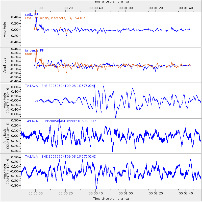
Signal To Noise
| Channel | StoN | STA | LTA |
| TA:LAVA: :BHN:20050504T09:08:16.575024Z | 1.4183233 | 5.853346E-8 | 4.1269477E-8 |
| TA:LAVA: :BHE:20050504T09:08:16.575024Z | 1.1084708 | 5.1801088E-8 | 4.673203E-8 |
| TA:LAVA: :BHZ:20050504T09:08:16.575024Z | 1.8898197 | 1.1775573E-7 | 6.231056E-8 |
| Arrivals |
| Ps | 3.7 SECOND |
| PpPs | 12 SECOND |
| PsPs/PpSs | 15 SECOND |


