You are here: Home > Network List > TA - USArray Transportable Network (new EarthScope stations) Stations List
> Station LAVA Lava Cap Winery, Placerville, CA, USA > Earthquake Result Viewer
LAVA Lava Cap Winery, Placerville, CA, USA - Earthquake Result Viewer
| Earthquake location: |
Bonin Islands, Japan Region |
| Earthquake latitude/longitude: |
26.1/144.0 |
| Earthquake time(UTC): |
2005/02/09 (040) 18:46:09 GMT |
| Earthquake Depth: |
24 km |
| Earthquake Magnitude: |
6.2 MB, 6.3 MS, 6.3 MW, 6.3 MW |
| Earthquake Catalog/Contributor: |
WHDF/NEIC |
|
| Network: |
TA USArray Transportable Network (new EarthScope stations) |
| Station: |
LAVA Lava Cap Winery, Placerville, CA, USA |
| Lat/Lon: |
38.76 N/120.74 W |
| Elevation: |
828 m |
|
| Distance: |
78.0 deg |
| Az: |
52.752 deg |
| Baz: |
293.716 deg |
| Ray Param: |
0.049923312 |
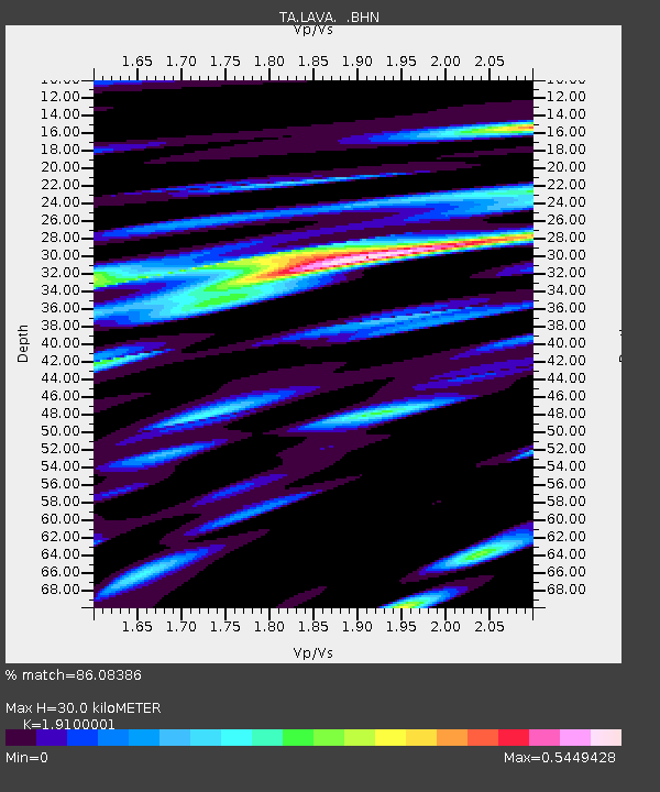
| Estimated Moho Depth: |
30.0 km |
| Estimated Crust Vp/Vs: |
1.91 |
| Assumed Crust Vp: |
6.597 km/s |
| Estimated Crust Vs: |
3.454 km/s |
| Estimated Crust Poisson's Ratio: |
0.31 |
|
| Radial Match: |
86.08386 % |
| Radial Bump: |
400 |
| Transverse Match: |
75.50862 % |
| Transverse Bump: |
400 |
| SOD ConfigId: |
132717 |
| Insert Time: |
2010-03-06 03:51:29.652 +0000 |
| GWidth: |
2.5 |
| Max Bumps: |
400 |
| Tol: |
0.001 |
|

Signal To Noise
| Channel | StoN | STA | LTA |
| TA:LAVA: :BHN:20050209T18:57:34.925017Z | 1.0089762 | 1.9842918E-7 | 1.9666389E-7 |
| TA:LAVA: :BHE:20050209T18:57:34.925017Z | 1.1393464 | 2.2677362E-7 | 1.9903835E-7 |
| TA:LAVA: :BHZ:20050209T18:57:34.925017Z | 2.095575 | 5.4218714E-7 | 2.5872953E-7 |
| Arrivals |
| Ps | 4.3 SECOND |
| PpPs | 13 SECOND |
| PsPs/PpSs | 17 SECOND |


