You are here: Home > Network List > CN - Canadian National Seismograph Network Stations List
> Station KGNO KINGSTON, ON > Earthquake Result Viewer
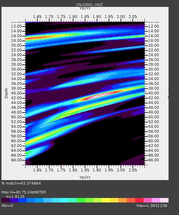
KGNO KINGSTON, ON - Earthquake Result Viewer
| Earthquake location: |
Central Mexico |
| Earthquake latitude/longitude: |
18.6/-98.5 |
| Earthquake time(UTC): |
2017/09/19 (262) 18:14:38 GMT |
| Earthquake Depth: |
51 km |
| Earthquake Magnitude: |
7.1 Mww |
| Earthquake Catalog/Contributor: |
NEIC PDE/us |
|
| Network: |
CN Canadian National Seismograph Network |
| Station: |
KGNO KINGSTON, ON |
| Lat/Lon: |
44.23 N/76.49 W |
| Elevation: |
89 m |
|
| Distance: |
31.5 deg |
| Az: |
30.98 deg |
| Baz: |
222.784 deg |
| Ray Param: |
0.07892393 |
| Estimated Moho Depth: |
40.75 km |
| Estimated Crust Vp/Vs: |
1.91 |
| Assumed Crust Vp: |
6.577 km/s |
| Estimated Crust Vs: |
3.439 km/s |
| Estimated Crust Poisson's Ratio: |
0.31 |
|
| Radial Match: |
93.374664 % |
| Radial Bump: |
192 |
| Transverse Match: |
70.63668 % |
| Transverse Bump: |
400 |
| SOD ConfigId: |
13570011 |
| Insert Time: |
2019-04-28 19:41:06.470 +0000 |
| GWidth: |
2.5 |
| Max Bumps: |
400 |
| Tol: |
0.001 |
|

Signal To Noise
| Channel | StoN | STA | LTA |
| CN:KGNO: :HHZ:20170919T18:20:25.509996Z | 7.1515045 | 2.2678937E-6 | 3.171212E-7 |
| CN:KGNO: :HHN:20170919T18:20:25.509996Z | 4.597686 | 1.2305638E-6 | 2.6764855E-7 |
| CN:KGNO: :HHE:20170919T18:20:25.509996Z | 3.3281486 | 1.013341E-6 | 3.044759E-7 |
| Arrivals |
| Ps | 6.1 SECOND |
| PpPs | 17 SECOND |
| PsPs/PpSs | 23 SECOND |


