You are here: Home > Network List > TA - USArray Transportable Network (new EarthScope stations) Stations List
> Station LAVA Lava Cap Winery, Placerville, CA, USA > Earthquake Result Viewer
LAVA Lava Cap Winery, Placerville, CA, USA - Earthquake Result Viewer
| Earthquake location: |
Rat Islands, Aleutian Islands |
| Earthquake latitude/longitude: |
51.2/179.4 |
| Earthquake time(UTC): |
2005/06/14 (165) 17:10:16 GMT |
| Earthquake Depth: |
51 km |
| Earthquake Magnitude: |
6.0 MB, 6.8 MW, 6.6 MW |
| Earthquake Catalog/Contributor: |
WHDF/NEIC |
|
| Network: |
TA USArray Transportable Network (new EarthScope stations) |
| Station: |
LAVA Lava Cap Winery, Placerville, CA, USA |
| Lat/Lon: |
38.76 N/120.74 W |
| Elevation: |
828 m |
|
| Distance: |
43.0 deg |
| Az: |
82.699 deg |
| Baz: |
307.098 deg |
| Ray Param: |
0.07270919 |
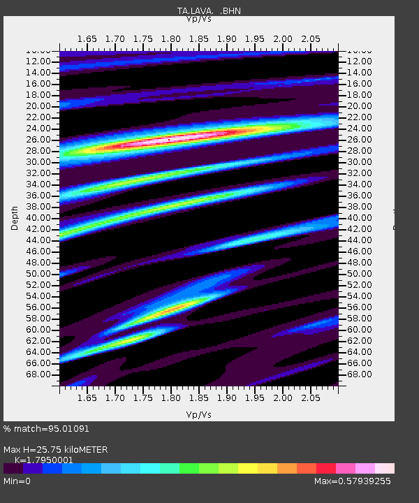
| Estimated Moho Depth: |
25.75 km |
| Estimated Crust Vp/Vs: |
1.80 |
| Assumed Crust Vp: |
6.597 km/s |
| Estimated Crust Vs: |
3.675 km/s |
| Estimated Crust Poisson's Ratio: |
0.27 |
|
| Radial Match: |
95.01091 % |
| Radial Bump: |
400 |
| Transverse Match: |
82.138275 % |
| Transverse Bump: |
400 |
| SOD ConfigId: |
144822 |
| Insert Time: |
2010-03-06 03:51:38.247 +0000 |
| GWidth: |
2.5 |
| Max Bumps: |
400 |
| Tol: |
0.001 |
|

Signal To Noise
| Channel | StoN | STA | LTA |
| TA:LAVA: :BHN:20050614T17:17:40.32399Z | 6.807876 | 6.257598E-7 | 9.191704E-8 |
| TA:LAVA: :BHE:20050614T17:17:40.32399Z | 5.049085 | 5.9097556E-7 | 1.1704607E-7 |
| TA:LAVA: :BHZ:20050614T17:17:40.32399Z | 13.329077 | 1.527589E-6 | 1.1460576E-7 |
| Arrivals |
| Ps | 3.3 SECOND |
| PpPs | 10 SECOND |
| PsPs/PpSs | 14 SECOND |


