You are here: Home > Network List > IU - Global Seismograph Network (GSN - IRIS/USGS) Stations List
> Station XMAS Kiritimati Island, Republic of Kiribati > Earthquake Result Viewer
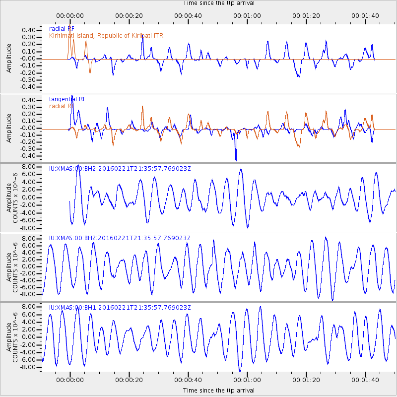
XMAS Kiritimati Island, Republic of Kiribati - Earthquake Result Viewer
*The percent match for this event was below the threshold and hence no stack was calculated.
| Earthquake location: |
Volcano Islands, Japan Region |
| Earthquake latitude/longitude: |
23.6/144.3 |
| Earthquake time(UTC): |
2016/02/21 (052) 21:26:23 GMT |
| Earthquake Depth: |
30 km |
| Earthquake Magnitude: |
5.6 MB |
| Earthquake Catalog/Contributor: |
NEIC PDE/NEIC COMCAT |
|
| Network: |
IU Global Seismograph Network (GSN - IRIS/USGS) |
| Station: |
XMAS Kiritimati Island, Republic of Kiribati |
| Lat/Lon: |
2.04 N/157.45 W |
| Elevation: |
20 m |
|
| Distance: |
60.2 deg |
| Az: |
101.751 deg |
| Baz: |
296.008 deg |
| Ray Param: |
$rayparam |
*The percent match for this event was below the threshold and hence was not used in the summary stack. |
|
| Radial Match: |
58.189655 % |
| Radial Bump: |
385 |
| Transverse Match: |
55.744415 % |
| Transverse Bump: |
400 |
| SOD ConfigId: |
1427151 |
| Insert Time: |
2016-03-06 22:03:49.885 +0000 |
| GWidth: |
2.5 |
| Max Bumps: |
400 |
| Tol: |
0.001 |
|
Signal To Noise
| Channel | StoN | STA | LTA |
| IU:XMAS:00:BHZ:20160221T21:35:57.769023Z | 0.8860235 | 3.918681E-6 | 4.422773E-6 |
| IU:XMAS:00:BH1:20160221T21:35:57.769023Z | 1.6791929 | 5.590787E-6 | 3.3294489E-6 |
| IU:XMAS:00:BH2:20160221T21:35:57.769023Z | 0.8847398 | 2.844404E-6 | 3.214961E-6 |
| Arrivals |
| Ps | |
| PpPs | |
| PsPs/PpSs | |


