You are here: Home > Network List > CN - Canadian National Seismograph Network Stations List
> Station YUK7 Dusty Glacier, YT, CA > Earthquake Result Viewer
YUK7 Dusty Glacier, YT, CA - Earthquake Result Viewer
| Earthquake location: |
Central Mexico |
| Earthquake latitude/longitude: |
18.6/-98.5 |
| Earthquake time(UTC): |
2017/09/19 (262) 18:14:38 GMT |
| Earthquake Depth: |
51 km |
| Earthquake Magnitude: |
7.1 Mww |
| Earthquake Catalog/Contributor: |
NEIC PDE/us |
|
| Network: |
CN Canadian National Seismograph Network |
| Station: |
YUK7 Dusty Glacier, YT, CA |
| Lat/Lon: |
60.53 N/138.14 W |
| Elevation: |
1992 m |
|
| Distance: |
50.5 deg |
| Az: |
335.866 deg |
| Baz: |
128.331 deg |
| Ray Param: |
0.06788111 |
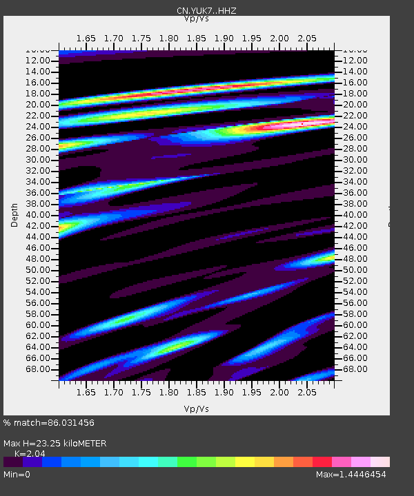
| Estimated Moho Depth: |
23.25 km |
| Estimated Crust Vp/Vs: |
2.04 |
| Assumed Crust Vp: |
6.566 km/s |
| Estimated Crust Vs: |
3.219 km/s |
| Estimated Crust Poisson's Ratio: |
0.34 |
|
| Radial Match: |
86.031456 % |
| Radial Bump: |
400 |
| Transverse Match: |
78.97441 % |
| Transverse Bump: |
400 |
| SOD ConfigId: |
13570011 |
| Insert Time: |
2019-04-28 19:41:41.563 +0000 |
| GWidth: |
2.5 |
| Max Bumps: |
400 |
| Tol: |
0.001 |
|

Signal To Noise
| Channel | StoN | STA | LTA |
| CN:YUK7: :HHZ:20170919T18:23:00.770006Z | 39.361324 | 4.196352E-6 | 1.06611054E-7 |
| CN:YUK7: :HHN:20170919T18:23:00.770006Z | 7.4777956 | 1.880153E-6 | 2.5143146E-7 |
| CN:YUK7: :HHE:20170919T18:23:00.770006Z | 7.447441 | 1.719054E-6 | 2.308248E-7 |
| Arrivals |
| Ps | 3.9 SECOND |
| PpPs | 10 SECOND |
| PsPs/PpSs | 14 SECOND |


