You are here: Home > Network List > TA - USArray Transportable Network (new EarthScope stations) Stations List
> Station LAVA Lava Cap Winery, Placerville, CA, USA > Earthquake Result Viewer
LAVA Lava Cap Winery, Placerville, CA, USA - Earthquake Result Viewer
| Earthquake location: |
Kermadec Islands Region |
| Earthquake latitude/longitude: |
-27.0/-176.3 |
| Earthquake time(UTC): |
2005/07/11 (192) 23:06:01 GMT |
| Earthquake Depth: |
10 km |
| Earthquake Magnitude: |
5.5 MB, 5.7 MS, 6.0 MW, 5.9 MW |
| Earthquake Catalog/Contributor: |
WHDF/NEIC |
|
| Network: |
TA USArray Transportable Network (new EarthScope stations) |
| Station: |
LAVA Lava Cap Winery, Placerville, CA, USA |
| Lat/Lon: |
38.76 N/120.74 W |
| Elevation: |
828 m |
|
| Distance: |
83.5 deg |
| Az: |
40.477 deg |
| Baz: |
227.796 deg |
| Ray Param: |
0.046126507 |
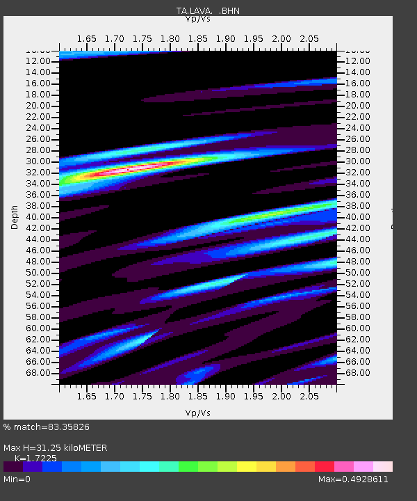
| Estimated Moho Depth: |
31.25 km |
| Estimated Crust Vp/Vs: |
1.72 |
| Assumed Crust Vp: |
6.597 km/s |
| Estimated Crust Vs: |
3.83 km/s |
| Estimated Crust Poisson's Ratio: |
0.25 |
|
| Radial Match: |
83.35826 % |
| Radial Bump: |
370 |
| Transverse Match: |
68.577484 % |
| Transverse Bump: |
400 |
| SOD ConfigId: |
2475 |
| Insert Time: |
2010-03-06 03:51:44.145 +0000 |
| GWidth: |
2.5 |
| Max Bumps: |
400 |
| Tol: |
0.001 |
|

Signal To Noise
| Channel | StoN | STA | LTA |
| TA:LAVA: :BHN:20050711T23:17:58.273997Z | 1.9003614 | 1.0848624E-7 | 5.7087163E-8 |
| TA:LAVA: :BHE:20050711T23:17:58.273997Z | 1.1839322 | 7.604225E-8 | 6.422855E-8 |
| TA:LAVA: :BHZ:20050711T23:17:58.273997Z | 6.0821624 | 3.9263966E-7 | 6.455593E-8 |
| Arrivals |
| Ps | 3.5 SECOND |
| PpPs | 13 SECOND |
| PsPs/PpSs | 16 SECOND |


