You are here: Home > Network List > US - United States National Seismic Network Stations List
> Station AMTX Amarillo, Texas, USA > Earthquake Result Viewer
AMTX Amarillo, Texas, USA - Earthquake Result Viewer
*The percent match for this event was below the threshold and hence no stack was calculated.
| Earthquake location: |
Volcano Islands, Japan Region |
| Earthquake latitude/longitude: |
23.6/144.3 |
| Earthquake time(UTC): |
2016/02/21 (052) 21:26:23 GMT |
| Earthquake Depth: |
30 km |
| Earthquake Magnitude: |
5.6 MB |
| Earthquake Catalog/Contributor: |
NEIC PDE/NEIC COMCAT |
|
| Network: |
US United States National Seismic Network |
| Station: |
AMTX Amarillo, Texas, USA |
| Lat/Lon: |
34.53 N/101.41 W |
| Elevation: |
1010 m |
|
| Distance: |
95.0 deg |
| Az: |
49.06 deg |
| Baz: |
302.924 deg |
| Ray Param: |
$rayparam |
*The percent match for this event was below the threshold and hence was not used in the summary stack. |
|
| Radial Match: |
60.724953 % |
| Radial Bump: |
400 |
| Transverse Match: |
45.549763 % |
| Transverse Bump: |
400 |
| SOD ConfigId: |
1427151 |
| Insert Time: |
2016-03-06 22:08:45.854 +0000 |
| GWidth: |
2.5 |
| Max Bumps: |
400 |
| Tol: |
0.001 |
|
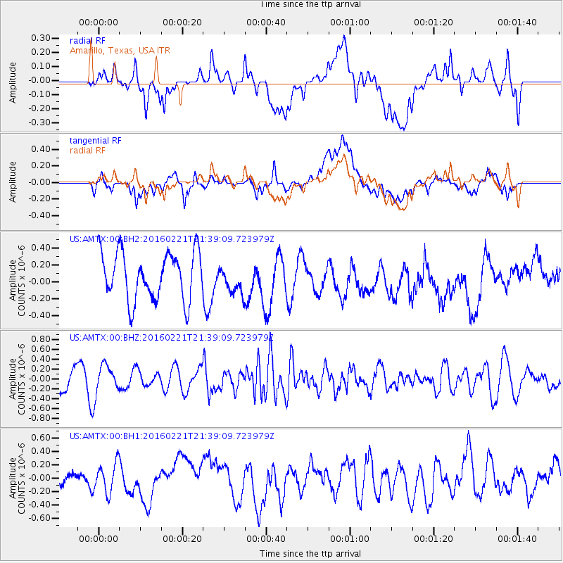
Signal To Noise
| Channel | StoN | STA | LTA |
| US:AMTX:00:BHZ:20160221T21:39:09.723979Z | 1.2122918 | 2.6760637E-7 | 2.2074418E-7 |
| US:AMTX:00:BH1:20160221T21:39:09.723979Z | 0.7183499 | 2.2110625E-7 | 3.0779745E-7 |
| US:AMTX:00:BH2:20160221T21:39:09.723979Z | 0.65787643 | 1.8891197E-7 | 2.8715417E-7 |
| Arrivals |
| Ps | |
| PpPs | |
| PsPs/PpSs | |


