You are here: Home > Network List > LD - Lamont-Doherty Cooperative Seismographic Network Stations List
> Station HCNY Howe Caverns, Cobleskill, NY > Earthquake Result Viewer
HCNY Howe Caverns, Cobleskill, NY - Earthquake Result Viewer
| Earthquake location: |
Central Mexico |
| Earthquake latitude/longitude: |
18.6/-98.5 |
| Earthquake time(UTC): |
2017/09/19 (262) 18:14:38 GMT |
| Earthquake Depth: |
51 km |
| Earthquake Magnitude: |
7.1 Mww |
| Earthquake Catalog/Contributor: |
NEIC PDE/us |
|
| Network: |
LD Lamont-Doherty Cooperative Seismographic Network |
| Station: |
HCNY Howe Caverns, Cobleskill, NY |
| Lat/Lon: |
42.70 N/74.40 W |
| Elevation: |
273 m |
|
| Distance: |
31.6 deg |
| Az: |
35.109 deg |
| Baz: |
227.739 deg |
| Ray Param: |
0.07892099 |
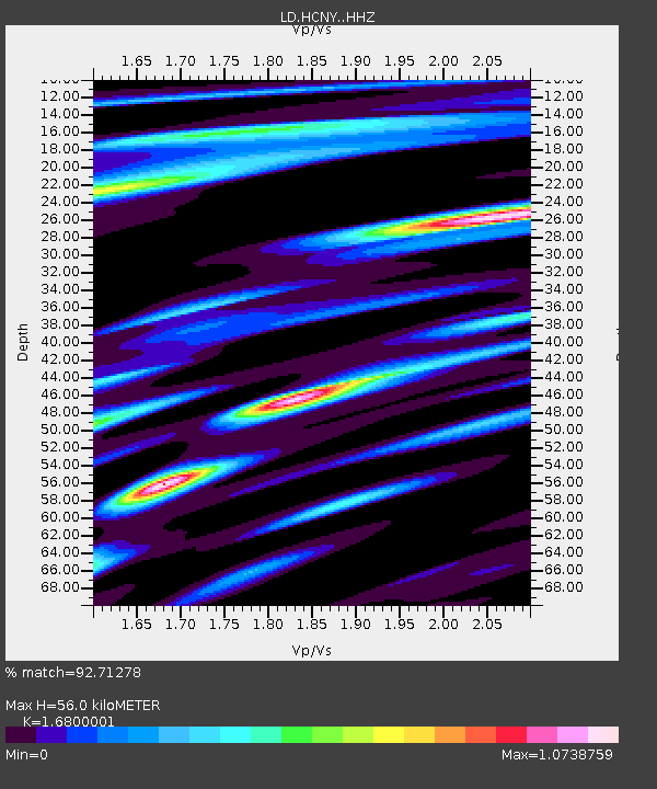
| Estimated Moho Depth: |
56.0 km |
| Estimated Crust Vp/Vs: |
1.68 |
| Assumed Crust Vp: |
6.419 km/s |
| Estimated Crust Vs: |
3.821 km/s |
| Estimated Crust Poisson's Ratio: |
0.23 |
|
| Radial Match: |
92.71278 % |
| Radial Bump: |
400 |
| Transverse Match: |
69.89672 % |
| Transverse Bump: |
400 |
| SOD ConfigId: |
13570011 |
| Insert Time: |
2019-04-28 19:42:59.323 +0000 |
| GWidth: |
2.5 |
| Max Bumps: |
400 |
| Tol: |
0.001 |
|

Signal To Noise
| Channel | StoN | STA | LTA |
| LD:HCNY: :HHZ:20170919T18:20:25.569994Z | 4.3797474 | 2.2245363E-6 | 5.0791425E-7 |
| LD:HCNY: :HHN:20170919T18:20:25.569994Z | 2.4064114 | 9.794068E-7 | 4.069989E-7 |
| LD:HCNY: :HHE:20170919T18:20:25.569994Z | 3.6501575 | 1.2633543E-6 | 3.4610952E-7 |
| Arrivals |
| Ps | 6.5 SECOND |
| PpPs | 21 SECOND |
| PsPs/PpSs | 28 SECOND |


