You are here: Home > Network List > N4 - Central and EAstern US Network Stations List
> Station G62A West of Eustis, ME, USA > Earthquake Result Viewer
G62A West of Eustis, ME, USA - Earthquake Result Viewer
| Earthquake location: |
Central Mexico |
| Earthquake latitude/longitude: |
18.6/-98.5 |
| Earthquake time(UTC): |
2017/09/19 (262) 18:14:38 GMT |
| Earthquake Depth: |
51 km |
| Earthquake Magnitude: |
7.1 Mww |
| Earthquake Catalog/Contributor: |
NEIC PDE/us |
|
| Network: |
N4 Central and EAstern US Network |
| Station: |
G62A West of Eustis, ME, USA |
| Lat/Lon: |
45.22 N/70.53 W |
| Elevation: |
426 m |
|
| Distance: |
35.3 deg |
| Az: |
34.979 deg |
| Baz: |
230.307 deg |
| Ray Param: |
0.07715926 |
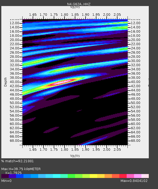
| Estimated Moho Depth: |
39.75 km |
| Estimated Crust Vp/Vs: |
1.79 |
| Assumed Crust Vp: |
6.419 km/s |
| Estimated Crust Vs: |
3.581 km/s |
| Estimated Crust Poisson's Ratio: |
0.27 |
|
| Radial Match: |
92.21881 % |
| Radial Bump: |
225 |
| Transverse Match: |
77.873764 % |
| Transverse Bump: |
400 |
| SOD ConfigId: |
13570011 |
| Insert Time: |
2019-04-28 19:43:22.558 +0000 |
| GWidth: |
2.5 |
| Max Bumps: |
400 |
| Tol: |
0.001 |
|

Signal To Noise
| Channel | StoN | STA | LTA |
| N4:G62A: :HHZ:20170919T18:20:58.18001Z | 6.775915 | 2.5539748E-6 | 3.7691953E-7 |
| N4:G62A: :HHN:20170919T18:20:58.18001Z | 3.756142 | 1.1252242E-6 | 2.9956917E-7 |
| N4:G62A: :HHE:20170919T18:20:58.18001Z | 3.949129 | 1.5424619E-6 | 3.905828E-7 |
| Arrivals |
| Ps | 5.3 SECOND |
| PpPs | 16 SECOND |
| PsPs/PpSs | 21 SECOND |


