You are here: Home > Network List > N4 - Central and EAstern US Network Stations List
> Station I63A Otisfield, ME, USA > Earthquake Result Viewer
I63A Otisfield, ME, USA - Earthquake Result Viewer
| Earthquake location: |
Central Mexico |
| Earthquake latitude/longitude: |
18.6/-98.5 |
| Earthquake time(UTC): |
2017/09/19 (262) 18:14:38 GMT |
| Earthquake Depth: |
51 km |
| Earthquake Magnitude: |
7.1 Mww |
| Earthquake Catalog/Contributor: |
NEIC PDE/us |
|
| Network: |
N4 Central and EAstern US Network |
| Station: |
I63A Otisfield, ME, USA |
| Lat/Lon: |
44.05 N/70.58 W |
| Elevation: |
177 m |
|
| Distance: |
34.6 deg |
| Az: |
36.524 deg |
| Baz: |
231.539 deg |
| Ray Param: |
0.077556804 |
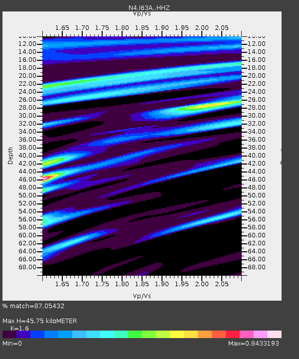
| Estimated Moho Depth: |
45.75 km |
| Estimated Crust Vp/Vs: |
1.60 |
| Assumed Crust Vp: |
6.419 km/s |
| Estimated Crust Vs: |
4.012 km/s |
| Estimated Crust Poisson's Ratio: |
0.18 |
|
| Radial Match: |
87.05432 % |
| Radial Bump: |
242 |
| Transverse Match: |
66.444916 % |
| Transverse Bump: |
400 |
| SOD ConfigId: |
13570011 |
| Insert Time: |
2019-04-28 19:43:24.552 +0000 |
| GWidth: |
2.5 |
| Max Bumps: |
400 |
| Tol: |
0.001 |
|

Signal To Noise
| Channel | StoN | STA | LTA |
| N4:I63A: :HHZ:20170919T18:20:51.620012Z | 4.6299305 | 2.1799897E-6 | 4.7084717E-7 |
| N4:I63A: :HHN:20170919T18:20:51.620012Z | 3.215553 | 1.0110045E-6 | 3.1441078E-7 |
| N4:I63A: :HHE:20170919T18:20:51.620012Z | 2.4319663 | 1.0723626E-6 | 4.409447E-7 |
| Arrivals |
| Ps | 4.7 SECOND |
| PpPs | 17 SECOND |
| PsPs/PpSs | 22 SECOND |


