You are here: Home > Network List > ON - RSIS-Rede Sismografica do Sul e Sudeste Observatorio Nacional, Brazil Stations List
> Station ALF01 "OBSN: [ALF01] Guarapari, ES" > Earthquake Result Viewer
ALF01 "OBSN: [ALF01] Guarapari, ES" - Earthquake Result Viewer
| Earthquake location: |
Central Mexico |
| Earthquake latitude/longitude: |
18.6/-98.5 |
| Earthquake time(UTC): |
2017/09/19 (262) 18:14:38 GMT |
| Earthquake Depth: |
51 km |
| Earthquake Magnitude: |
7.1 Mww |
| Earthquake Catalog/Contributor: |
NEIC PDE/us |
|
| Network: |
ON RSIS-Rede Sismografica do Sul e Sudeste Observatorio Nacional, Brazil |
| Station: |
ALF01 "OBSN: [ALF01] Guarapari, ES" |
| Lat/Lon: |
20.62 S/40.73 W |
| Elevation: |
22 m |
|
| Distance: |
68.7 deg |
| Az: |
121.736 deg |
| Baz: |
300.536 deg |
| Ray Param: |
0.056027684 |
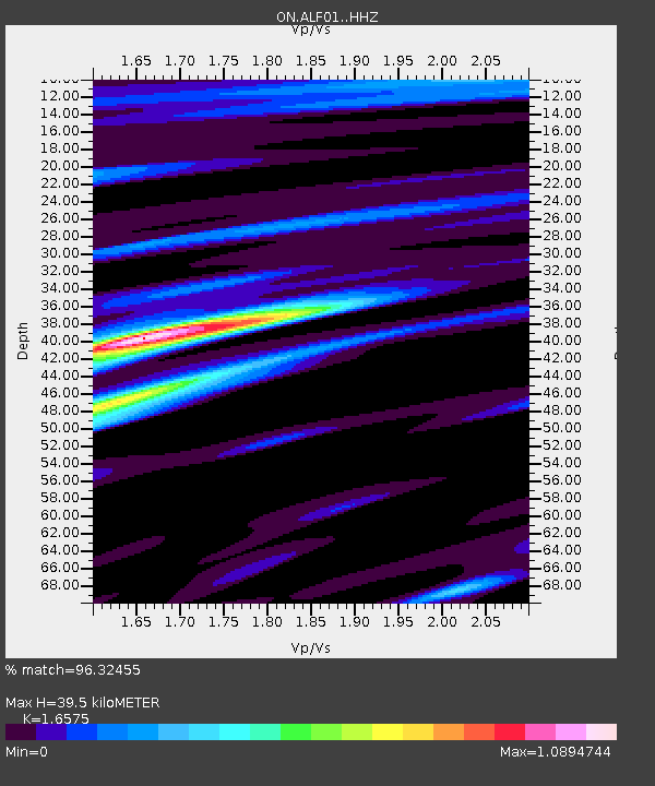
| Estimated Moho Depth: |
39.5 km |
| Estimated Crust Vp/Vs: |
1.66 |
| Assumed Crust Vp: |
6.472 km/s |
| Estimated Crust Vs: |
3.905 km/s |
| Estimated Crust Poisson's Ratio: |
0.21 |
|
| Radial Match: |
96.32455 % |
| Radial Bump: |
400 |
| Transverse Match: |
86.15157 % |
| Transverse Bump: |
400 |
| SOD ConfigId: |
13570011 |
| Insert Time: |
2019-04-28 19:43:42.473 +0000 |
| GWidth: |
2.5 |
| Max Bumps: |
400 |
| Tol: |
0.001 |
|

Signal To Noise
| Channel | StoN | STA | LTA |
| ON:ALF01: :HHZ:20170919T18:25:05.808Z | 21.04575 | 6.763985E-6 | 3.2139434E-7 |
| ON:ALF01: :HHN:20170919T18:25:05.808Z | 8.134947 | 1.535163E-6 | 1.8871214E-7 |
| ON:ALF01: :HHE:20170919T18:25:05.808Z | 8.281248 | 2.378739E-6 | 2.8724403E-7 |
| Arrivals |
| Ps | 4.2 SECOND |
| PpPs | 16 SECOND |
| PsPs/PpSs | 20 SECOND |


