You are here: Home > Network List > ON - RSIS-Rede Sismografica do Sul e Sudeste Observatorio Nacional, Brazil Stations List
> Station NAN01 "OBSN: [NAN01] Nanuque, MG" > Earthquake Result Viewer
NAN01 "OBSN: [NAN01] Nanuque, MG" - Earthquake Result Viewer
| Earthquake location: |
Central Mexico |
| Earthquake latitude/longitude: |
18.6/-98.5 |
| Earthquake time(UTC): |
2017/09/19 (262) 18:14:38 GMT |
| Earthquake Depth: |
51 km |
| Earthquake Magnitude: |
7.1 Mww |
| Earthquake Catalog/Contributor: |
NEIC PDE/us |
|
| Network: |
ON RSIS-Rede Sismografica do Sul e Sudeste Observatorio Nacional, Brazil |
| Station: |
NAN01 "OBSN: [NAN01] Nanuque, MG" |
| Lat/Lon: |
17.84 S/40.13 W |
| Elevation: |
206 m |
|
| Distance: |
67.8 deg |
| Az: |
118.858 deg |
| Baz: |
299.273 deg |
| Ray Param: |
0.056604505 |
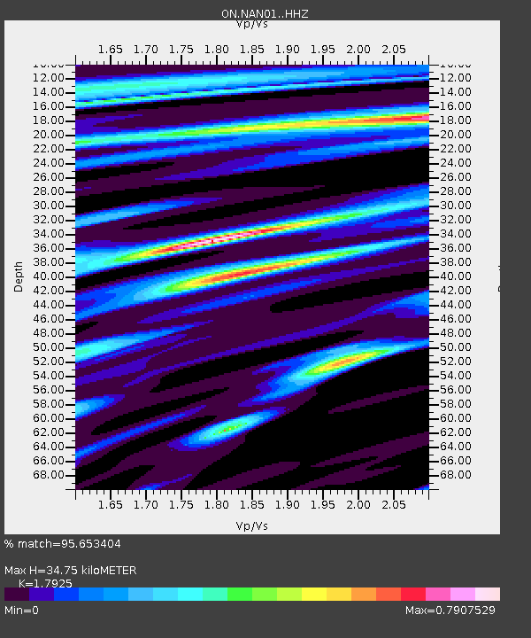
| Estimated Moho Depth: |
34.75 km |
| Estimated Crust Vp/Vs: |
1.79 |
| Assumed Crust Vp: |
6.459 km/s |
| Estimated Crust Vs: |
3.604 km/s |
| Estimated Crust Poisson's Ratio: |
0.27 |
|
| Radial Match: |
95.653404 % |
| Radial Bump: |
400 |
| Transverse Match: |
83.12386 % |
| Transverse Bump: |
400 |
| SOD ConfigId: |
13570011 |
| Insert Time: |
2019-04-28 19:43:45.273 +0000 |
| GWidth: |
2.5 |
| Max Bumps: |
400 |
| Tol: |
0.001 |
|

Signal To Noise
| Channel | StoN | STA | LTA |
| ON:NAN01: :HHZ:20170919T18:25:00.287981Z | 15.575581 | 5.2254586E-6 | 3.3549045E-7 |
| ON:NAN01: :HH1:20170919T18:25:00.287981Z | 4.4266987 | 1.3523243E-6 | 3.0549273E-7 |
| ON:NAN01: :HH2:20170919T18:25:00.287981Z | 8.35075 | 2.446664E-6 | 2.9298732E-7 |
| Arrivals |
| Ps | 4.4 SECOND |
| PpPs | 14 SECOND |
| PsPs/PpSs | 19 SECOND |


