You are here: Home > Network List > OX - North-East Italy Seismic Network Stations List
> Station DRE Drenchia > Earthquake Result Viewer
DRE Drenchia - Earthquake Result Viewer
| Earthquake location: |
Central Mexico |
| Earthquake latitude/longitude: |
18.6/-98.5 |
| Earthquake time(UTC): |
2017/09/19 (262) 18:14:38 GMT |
| Earthquake Depth: |
51 km |
| Earthquake Magnitude: |
7.1 Mww |
| Earthquake Catalog/Contributor: |
NEIC PDE/us |
|
| Network: |
OX North-East Italy Seismic Network |
| Station: |
DRE Drenchia |
| Lat/Lon: |
46.17 N/13.65 E |
| Elevation: |
810 m |
|
| Distance: |
91.2 deg |
| Az: |
40.076 deg |
| Baz: |
298.489 deg |
| Ray Param: |
0.041610744 |
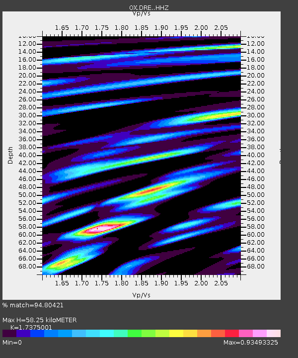
| Estimated Moho Depth: |
58.25 km |
| Estimated Crust Vp/Vs: |
1.74 |
| Assumed Crust Vp: |
6.35 km/s |
| Estimated Crust Vs: |
3.655 km/s |
| Estimated Crust Poisson's Ratio: |
0.25 |
|
| Radial Match: |
94.80421 % |
| Radial Bump: |
400 |
| Transverse Match: |
92.487724 % |
| Transverse Bump: |
400 |
| SOD ConfigId: |
13570011 |
| Insert Time: |
2019-04-28 19:43:52.963 +0000 |
| GWidth: |
2.5 |
| Max Bumps: |
400 |
| Tol: |
0.001 |
|

Signal To Noise
| Channel | StoN | STA | LTA |
| OX:DRE: :HHZ:20170919T18:27:06.68001Z | 19.980862 | 2.6343455E-6 | 1.3184344E-7 |
| OX:DRE: :HHN:20170919T18:27:06.68001Z | 7.6000013 | 1.0376745E-6 | 1.3653609E-7 |
| OX:DRE: :HHE:20170919T18:27:06.68001Z | 6.829571 | 7.1081513E-7 | 1.04079035E-7 |
| Arrivals |
| Ps | 6.9 SECOND |
| PpPs | 25 SECOND |
| PsPs/PpSs | 32 SECOND |


