You are here: Home > Network List > TA - USArray Transportable Network (new EarthScope stations) Stations List
> Station A21K Barrow, AK, USA > Earthquake Result Viewer
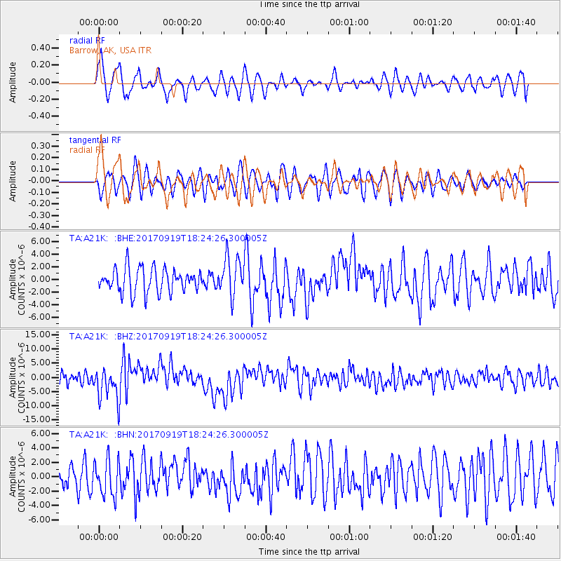
A21K Barrow, AK, USA - Earthquake Result Viewer
*The percent match for this event was below the threshold and hence no stack was calculated.
| Earthquake location: |
Central Mexico |
| Earthquake latitude/longitude: |
18.6/-98.5 |
| Earthquake time(UTC): |
2017/09/19 (262) 18:14:38 GMT |
| Earthquake Depth: |
51 km |
| Earthquake Magnitude: |
7.1 Mww |
| Earthquake Catalog/Contributor: |
NEIC PDE/us |
|
| Network: |
TA USArray Transportable Network (new EarthScope stations) |
| Station: |
A21K Barrow, AK, USA |
| Lat/Lon: |
71.32 N/156.62 W |
| Elevation: |
577 m |
|
| Distance: |
62.6 deg |
| Az: |
342.045 deg |
| Baz: |
114.809 deg |
| Ray Param: |
$rayparam |
*The percent match for this event was below the threshold and hence was not used in the summary stack. |
|
| Radial Match: |
68.0592 % |
| Radial Bump: |
400 |
| Transverse Match: |
53.671772 % |
| Transverse Bump: |
400 |
| SOD ConfigId: |
13570011 |
| Insert Time: |
2019-04-28 19:44:40.747 +0000 |
| GWidth: |
2.5 |
| Max Bumps: |
400 |
| Tol: |
0.001 |
|
Signal To Noise
| Channel | StoN | STA | LTA |
| TA:A21K: :BHZ:20170919T18:24:26.300005Z | 3.3114352 | 5.888311E-6 | 1.778175E-6 |
| TA:A21K: :BHN:20170919T18:24:26.300005Z | 1.7732724 | 2.5872391E-6 | 1.4590196E-6 |
| TA:A21K: :BHE:20170919T18:24:26.300005Z | 1.6841279 | 3.1925372E-6 | 1.895662E-6 |
| Arrivals |
| Ps | |
| PpPs | |
| PsPs/PpSs | |


