You are here: Home > Network List > TA - USArray Transportable Network (new EarthScope stations) Stations List
> Station F25K Christian River, AK, USA > Earthquake Result Viewer
F25K Christian River, AK, USA - Earthquake Result Viewer
| Earthquake location: |
Central Mexico |
| Earthquake latitude/longitude: |
18.6/-98.5 |
| Earthquake time(UTC): |
2017/09/19 (262) 18:14:38 GMT |
| Earthquake Depth: |
51 km |
| Earthquake Magnitude: |
7.1 Mww |
| Earthquake Catalog/Contributor: |
NEIC PDE/us |
|
| Network: |
TA USArray Transportable Network (new EarthScope stations) |
| Station: |
F25K Christian River, AK, USA |
| Lat/Lon: |
67.59 N/145.64 W |
| Elevation: |
864 m |
|
| Distance: |
57.4 deg |
| Az: |
340.501 deg |
| Baz: |
124.313 deg |
| Ray Param: |
0.06342772 |
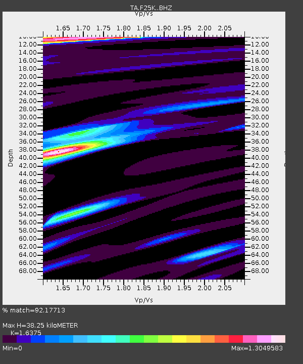
| Estimated Moho Depth: |
38.25 km |
| Estimated Crust Vp/Vs: |
1.64 |
| Assumed Crust Vp: |
6.522 km/s |
| Estimated Crust Vs: |
3.983 km/s |
| Estimated Crust Poisson's Ratio: |
0.20 |
|
| Radial Match: |
92.17713 % |
| Radial Bump: |
353 |
| Transverse Match: |
73.43083 % |
| Transverse Bump: |
400 |
| SOD ConfigId: |
13570011 |
| Insert Time: |
2019-04-28 19:45:16.443 +0000 |
| GWidth: |
2.5 |
| Max Bumps: |
400 |
| Tol: |
0.001 |
|

Signal To Noise
| Channel | StoN | STA | LTA |
| TA:F25K: :BHZ:20170919T18:23:50.675005Z | 26.712347 | 3.8324697E-6 | 1.4347185E-7 |
| TA:F25K: :BHN:20170919T18:23:50.675005Z | 5.7260647 | 9.053925E-7 | 1.5811774E-7 |
| TA:F25K: :BHE:20170919T18:23:50.675005Z | 10.695379 | 1.2996755E-6 | 1.2151749E-7 |
| Arrivals |
| Ps | 4.0 SECOND |
| PpPs | 15 SECOND |
| PsPs/PpSs | 19 SECOND |


