You are here: Home > Network List > TA - USArray Transportable Network (new EarthScope stations) Stations List
> Station G19K Purcell Mountains, AK, USA > Earthquake Result Viewer
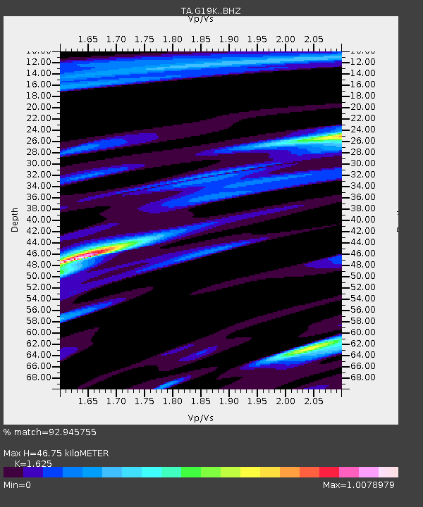
G19K Purcell Mountains, AK, USA - Earthquake Result Viewer
| Earthquake location: |
Central Mexico |
| Earthquake latitude/longitude: |
18.6/-98.5 |
| Earthquake time(UTC): |
2017/09/19 (262) 18:14:38 GMT |
| Earthquake Depth: |
51 km |
| Earthquake Magnitude: |
7.1 Mww |
| Earthquake Catalog/Contributor: |
NEIC PDE/us |
|
| Network: |
TA USArray Transportable Network (new EarthScope stations) |
| Station: |
G19K Purcell Mountains, AK, USA |
| Lat/Lon: |
66.14 N/157.09 W |
| Elevation: |
391 m |
|
| Distance: |
60.7 deg |
| Az: |
336.533 deg |
| Baz: |
111.749 deg |
| Ray Param: |
0.061270148 |
| Estimated Moho Depth: |
46.75 km |
| Estimated Crust Vp/Vs: |
1.62 |
| Assumed Crust Vp: |
6.577 km/s |
| Estimated Crust Vs: |
4.047 km/s |
| Estimated Crust Poisson's Ratio: |
0.20 |
|
| Radial Match: |
92.945755 % |
| Radial Bump: |
400 |
| Transverse Match: |
85.32006 % |
| Transverse Bump: |
400 |
| SOD ConfigId: |
13570011 |
| Insert Time: |
2019-04-28 19:45:22.103 +0000 |
| GWidth: |
2.5 |
| Max Bumps: |
400 |
| Tol: |
0.001 |
|

Signal To Noise
| Channel | StoN | STA | LTA |
| TA:G19K: :BHZ:20170919T18:24:13.52498Z | 29.117779 | 5.8355054E-6 | 2.0041038E-7 |
| TA:G19K: :BHN:20170919T18:24:13.52498Z | 19.168945 | 2.0361279E-6 | 1.06220135E-7 |
| TA:G19K: :BHE:20170919T18:24:13.52498Z | 23.801598 | 3.0166523E-6 | 1.2674158E-7 |
| Arrivals |
| Ps | 4.7 SECOND |
| PpPs | 18 SECOND |
| PsPs/PpSs | 22 SECOND |


