You are here: Home > Network List > TA - USArray Transportable Network (new EarthScope stations) Stations List
> Station H20K Anotleneega Mountain, AK, USA > Earthquake Result Viewer
H20K Anotleneega Mountain, AK, USA - Earthquake Result Viewer
| Earthquake location: |
Central Mexico |
| Earthquake latitude/longitude: |
18.6/-98.5 |
| Earthquake time(UTC): |
2017/09/19 (262) 18:14:38 GMT |
| Earthquake Depth: |
51 km |
| Earthquake Magnitude: |
7.1 Mww |
| Earthquake Catalog/Contributor: |
NEIC PDE/us |
|
| Network: |
TA USArray Transportable Network (new EarthScope stations) |
| Station: |
H20K Anotleneega Mountain, AK, USA |
| Lat/Lon: |
65.49 N/154.88 W |
| Elevation: |
514 m |
|
| Distance: |
59.6 deg |
| Az: |
336.242 deg |
| Baz: |
113.614 deg |
| Ray Param: |
0.061985414 |
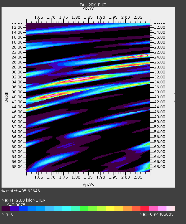
| Estimated Moho Depth: |
23.0 km |
| Estimated Crust Vp/Vs: |
2.09 |
| Assumed Crust Vp: |
6.566 km/s |
| Estimated Crust Vs: |
3.145 km/s |
| Estimated Crust Poisson's Ratio: |
0.35 |
|
| Radial Match: |
95.63646 % |
| Radial Bump: |
400 |
| Transverse Match: |
84.50715 % |
| Transverse Bump: |
400 |
| SOD ConfigId: |
13570011 |
| Insert Time: |
2019-04-28 19:45:35.322 +0000 |
| GWidth: |
2.5 |
| Max Bumps: |
400 |
| Tol: |
0.001 |
|

Signal To Noise
| Channel | StoN | STA | LTA |
| TA:H20K: :BHZ:20170919T18:24:06.075029Z | 24.830723 | 5.55005E-6 | 2.2351544E-7 |
| TA:H20K: :BHN:20170919T18:24:06.075029Z | 8.950758 | 1.0894096E-6 | 1.2171144E-7 |
| TA:H20K: :BHE:20170919T18:24:06.075029Z | 20.10016 | 2.4072835E-6 | 1.1976441E-7 |
| Arrivals |
| Ps | 4.0 SECOND |
| PpPs | 10 SECOND |
| PsPs/PpSs | 14 SECOND |


