You are here: Home > Network List > TA - USArray Transportable Network (new EarthScope stations) Stations List
> Station H21K Melozitna River, AK, USA > Earthquake Result Viewer
H21K Melozitna River, AK, USA - Earthquake Result Viewer
| Earthquake location: |
Central Mexico |
| Earthquake latitude/longitude: |
18.6/-98.5 |
| Earthquake time(UTC): |
2017/09/19 (262) 18:14:38 GMT |
| Earthquake Depth: |
51 km |
| Earthquake Magnitude: |
7.1 Mww |
| Earthquake Catalog/Contributor: |
NEIC PDE/us |
|
| Network: |
TA USArray Transportable Network (new EarthScope stations) |
| Station: |
H21K Melozitna River, AK, USA |
| Lat/Lon: |
65.66 N/152.80 W |
| Elevation: |
520 m |
|
| Distance: |
58.9 deg |
| Az: |
336.837 deg |
| Baz: |
115.806 deg |
| Ray Param: |
0.06245614 |
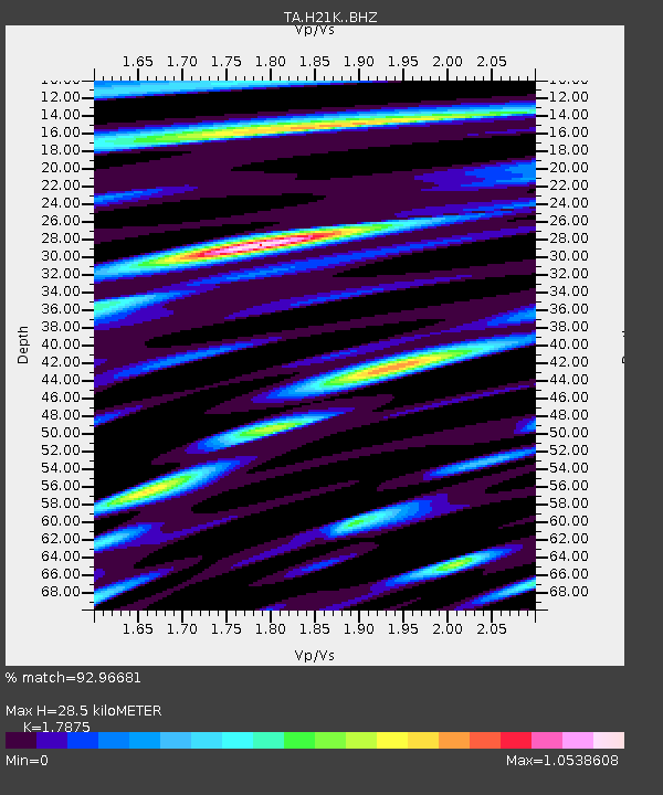
| Estimated Moho Depth: |
28.5 km |
| Estimated Crust Vp/Vs: |
1.79 |
| Assumed Crust Vp: |
6.566 km/s |
| Estimated Crust Vs: |
3.673 km/s |
| Estimated Crust Poisson's Ratio: |
0.27 |
|
| Radial Match: |
92.96681 % |
| Radial Bump: |
400 |
| Transverse Match: |
82.96049 % |
| Transverse Bump: |
400 |
| SOD ConfigId: |
13570011 |
| Insert Time: |
2019-04-28 19:45:35.385 +0000 |
| GWidth: |
2.5 |
| Max Bumps: |
400 |
| Tol: |
0.001 |
|

Signal To Noise
| Channel | StoN | STA | LTA |
| TA:H21K: :BHZ:20170919T18:24:01.14998Z | 43.98151 | 4.9627993E-6 | 1.1283831E-7 |
| TA:H21K: :BHN:20170919T18:24:01.14998Z | 8.762668 | 8.9836675E-7 | 1.02522066E-7 |
| TA:H21K: :BHE:20170919T18:24:01.14998Z | 29.251928 | 2.1951384E-6 | 7.5042514E-8 |
| Arrivals |
| Ps | 3.6 SECOND |
| PpPs | 12 SECOND |
| PsPs/PpSs | 15 SECOND |


