You are here: Home > Network List > TA - USArray Transportable Network (new EarthScope stations) Stations List
> Station LAVA Lava Cap Winery, Placerville, CA, USA > Earthquake Result Viewer
LAVA Lava Cap Winery, Placerville, CA, USA - Earthquake Result Viewer
| Earthquake location: |
Kamchatka Peninsula, Russia |
| Earthquake latitude/longitude: |
54.3/158.4 |
| Earthquake time(UTC): |
2006/05/22 (142) 13:08:01 GMT |
| Earthquake Depth: |
185 km |
| Earthquake Magnitude: |
6.2 MB, 6.2 MW, 6.2 MW |
| Earthquake Catalog/Contributor: |
WHDF/NEIC |
|
| Network: |
TA USArray Transportable Network (new EarthScope stations) |
| Station: |
LAVA Lava Cap Winery, Placerville, CA, USA |
| Lat/Lon: |
38.76 N/120.74 W |
| Elevation: |
828 m |
|
| Distance: |
54.7 deg |
| Az: |
71.073 deg |
| Baz: |
314.807 deg |
| Ray Param: |
0.06465656 |
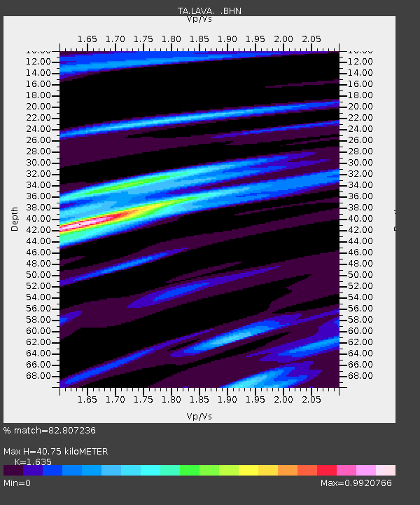
| Estimated Moho Depth: |
40.75 km |
| Estimated Crust Vp/Vs: |
1.63 |
| Assumed Crust Vp: |
6.597 km/s |
| Estimated Crust Vs: |
4.035 km/s |
| Estimated Crust Poisson's Ratio: |
0.20 |
|
| Radial Match: |
82.807236 % |
| Radial Bump: |
400 |
| Transverse Match: |
71.20242 % |
| Transverse Bump: |
400 |
| SOD ConfigId: |
2669 |
| Insert Time: |
2010-03-06 03:53:08.361 +0000 |
| GWidth: |
2.5 |
| Max Bumps: |
400 |
| Tol: |
0.001 |
|

Signal To Noise
| Channel | StoN | STA | LTA |
| TA:LAVA: :BHN:20060522T13:16:40.899004Z | 1.7798054 | 3.5775676E-7 | 2.0100892E-7 |
| TA:LAVA: :BHE:20060522T13:16:40.899004Z | 0.8453465 | 2.2725415E-7 | 2.6882958E-7 |
| TA:LAVA: :BHZ:20060522T13:16:40.899004Z | 3.1507967 | 6.6622493E-7 | 2.114465E-7 |
| Arrivals |
| Ps | 4.2 SECOND |
| PpPs | 15 SECOND |
| PsPs/PpSs | 19 SECOND |


