You are here: Home > Network List > TA - USArray Transportable Network (new EarthScope stations) Stations List
> Station LAVA Lava Cap Winery, Placerville, CA, USA > Earthquake Result Viewer
LAVA Lava Cap Winery, Placerville, CA, USA - Earthquake Result Viewer
| Earthquake location: |
Eastern Siberia, Russia |
| Earthquake latitude/longitude: |
60.8/165.7 |
| Earthquake time(UTC): |
2006/05/22 (142) 11:12:00 GMT |
| Earthquake Depth: |
16 km |
| Earthquake Magnitude: |
6.0 MB, 6.7 MS, 6.6 MW, 6.5 MW |
| Earthquake Catalog/Contributor: |
WHDF/NEIC |
|
| Network: |
TA USArray Transportable Network (new EarthScope stations) |
| Station: |
LAVA Lava Cap Winery, Placerville, CA, USA |
| Lat/Lon: |
38.76 N/120.74 W |
| Elevation: |
828 m |
|
| Distance: |
49.3 deg |
| Az: |
81.444 deg |
| Baz: |
321.629 deg |
| Ray Param: |
0.068767466 |
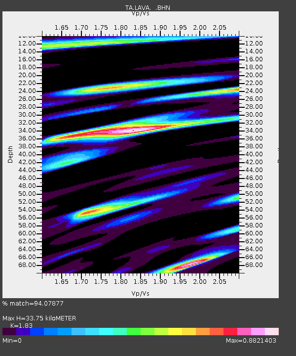
| Estimated Moho Depth: |
33.75 km |
| Estimated Crust Vp/Vs: |
1.83 |
| Assumed Crust Vp: |
6.597 km/s |
| Estimated Crust Vs: |
3.605 km/s |
| Estimated Crust Poisson's Ratio: |
0.29 |
|
| Radial Match: |
94.07877 % |
| Radial Bump: |
355 |
| Transverse Match: |
73.40095 % |
| Transverse Bump: |
400 |
| SOD ConfigId: |
2669 |
| Insert Time: |
2010-03-06 03:53:10.308 +0000 |
| GWidth: |
2.5 |
| Max Bumps: |
400 |
| Tol: |
0.001 |
|

Signal To Noise
| Channel | StoN | STA | LTA |
| TA:LAVA: :BHN:20060522T11:20:17.498011Z | 4.9653177 | 5.949737E-7 | 1.1982591E-7 |
| TA:LAVA: :BHE:20060522T11:20:17.498011Z | 7.0426035 | 3.999062E-7 | 5.678386E-8 |
| TA:LAVA: :BHZ:20060522T11:20:17.498011Z | 11.485084 | 1.1877984E-6 | 1.0342096E-7 |
| Arrivals |
| Ps | 4.5 SECOND |
| PpPs | 14 SECOND |
| PsPs/PpSs | 18 SECOND |


