You are here: Home > Network List > TA - USArray Transportable Network (new EarthScope stations) Stations List
> Station J26L Joseph Creek, AK, USA > Earthquake Result Viewer
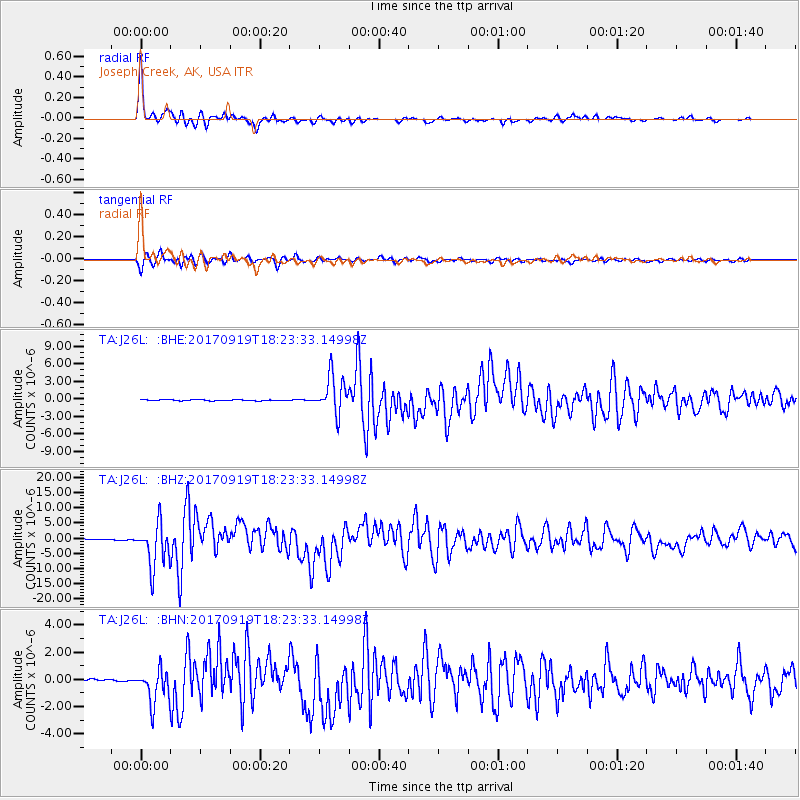
J26L Joseph Creek, AK, USA - Earthquake Result Viewer

| Earthquake location: |
Central Mexico |
| Earthquake latitude/longitude: |
18.6/-98.5 |
| Earthquake time(UTC): |
2017/09/19 (262) 18:14:38 GMT |
| Earthquake Depth: |
51 km |
| Earthquake Magnitude: |
7.1 Mww |
| Earthquake Catalog/Contributor: |
NEIC PDE/us |
|
| Network: |
TA USArray Transportable Network (new EarthScope stations) |
| Station: |
J26L Joseph Creek, AK, USA |
| Lat/Lon: |
64.50 N/143.56 W |
| Elevation: |
1144 m |
|
| Distance: |
54.9 deg |
| Az: |
338.001 deg |
| Baz: |
124.818 deg |
| Ray Param: |
0.065029666 |
| Estimated Moho Depth: |
39.5 km |
| Estimated Crust Vp/Vs: |
1.69 |
| Assumed Crust Vp: |
6.566 km/s |
| Estimated Crust Vs: |
3.897 km/s |
| Estimated Crust Poisson's Ratio: |
0.23 |
|
| Radial Match: |
96.48839 % |
| Radial Bump: |
299 |
| Transverse Match: |
91.64731 % |
| Transverse Bump: |
400 |
| SOD ConfigId: |
13570011 |
| Insert Time: |
2019-04-28 19:45:58.138 +0000 |
| GWidth: |
2.5 |
| Max Bumps: |
400 |
| Tol: |
0.001 |
|
Signal To Noise
| Channel | StoN | STA | LTA |
| TA:J26L: :BHZ:20170919T18:23:33.14998Z | 52.150078 | 7.1409754E-6 | 1.3693125E-7 |
| TA:J26L: :BHN:20170919T18:23:33.14998Z | 16.118439 | 1.2718145E-6 | 7.890433E-8 |
| TA:J26L: :BHE:20170919T18:23:33.14998Z | 34.91607 | 3.1550194E-6 | 9.0360096E-8 |
| Arrivals |
| Ps | 4.4 SECOND |
| PpPs | 15 SECOND |
| PsPs/PpSs | 20 SECOND |


