You are here: Home > Network List > TA - USArray Transportable Network (new EarthScope stations) Stations List
> Station LAVA Lava Cap Winery, Placerville, CA, USA > Earthquake Result Viewer
LAVA Lava Cap Winery, Placerville, CA, USA - Earthquake Result Viewer
| Earthquake location: |
Eastern Siberia, Russia |
| Earthquake latitude/longitude: |
60.5/167.5 |
| Earthquake time(UTC): |
2006/04/29 (119) 16:58:06 GMT |
| Earthquake Depth: |
11 km |
| Earthquake Magnitude: |
6.4 MB, 6.6 MS, 6.6 MW, 6.4 MW |
| Earthquake Catalog/Contributor: |
WHDF/NEIC |
|
| Network: |
TA USArray Transportable Network (new EarthScope stations) |
| Station: |
LAVA Lava Cap Winery, Placerville, CA, USA |
| Lat/Lon: |
38.76 N/120.74 W |
| Elevation: |
828 m |
|
| Distance: |
48.5 deg |
| Az: |
82.646 deg |
| Baz: |
321.099 deg |
| Ray Param: |
0.06933411 |
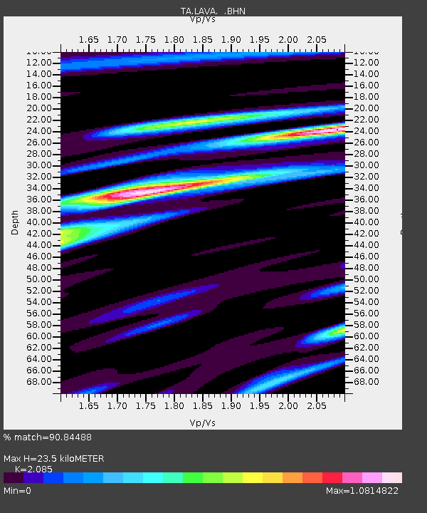
| Estimated Moho Depth: |
23.5 km |
| Estimated Crust Vp/Vs: |
2.09 |
| Assumed Crust Vp: |
6.597 km/s |
| Estimated Crust Vs: |
3.164 km/s |
| Estimated Crust Poisson's Ratio: |
0.35 |
|
| Radial Match: |
90.84488 % |
| Radial Bump: |
400 |
| Transverse Match: |
80.57675 % |
| Transverse Bump: |
400 |
| SOD ConfigId: |
2669 |
| Insert Time: |
2010-03-06 03:53:20.544 +0000 |
| GWidth: |
2.5 |
| Max Bumps: |
400 |
| Tol: |
0.001 |
|

Signal To Noise
| Channel | StoN | STA | LTA |
| TA:LAVA: :BHN:20060429T17:06:17.89901Z | 10.606661 | 8.5653534E-7 | 8.0754475E-8 |
| TA:LAVA: :BHE:20060429T17:06:17.89901Z | 7.144105 | 5.207785E-7 | 7.289625E-8 |
| TA:LAVA: :BHZ:20060429T17:06:17.89901Z | 17.86608 | 1.8448821E-6 | 1.0326172E-7 |
| Arrivals |
| Ps | 4.1 SECOND |
| PpPs | 10 SECOND |
| PsPs/PpSs | 14 SECOND |


