You are here: Home > Network List > TA - USArray Transportable Network (new EarthScope stations) Stations List
> Station O20K Slope Mountain, AK, USA > Earthquake Result Viewer
O20K Slope Mountain, AK, USA - Earthquake Result Viewer
| Earthquake location: |
Central Mexico |
| Earthquake latitude/longitude: |
18.6/-98.5 |
| Earthquake time(UTC): |
2017/09/19 (262) 18:14:38 GMT |
| Earthquake Depth: |
51 km |
| Earthquake Magnitude: |
7.1 Mww |
| Earthquake Catalog/Contributor: |
NEIC PDE/us |
|
| Network: |
TA USArray Transportable Network (new EarthScope stations) |
| Station: |
O20K Slope Mountain, AK, USA |
| Lat/Lon: |
60.08 N/152.62 W |
| Elevation: |
915 m |
|
| Distance: |
56.5 deg |
| Az: |
330.838 deg |
| Baz: |
112.756 deg |
| Ray Param: |
0.06399735 |
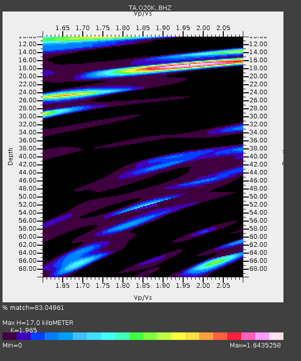
| Estimated Moho Depth: |
17.0 km |
| Estimated Crust Vp/Vs: |
1.97 |
| Assumed Crust Vp: |
6.566 km/s |
| Estimated Crust Vs: |
3.342 km/s |
| Estimated Crust Poisson's Ratio: |
0.33 |
|
| Radial Match: |
83.04961 % |
| Radial Bump: |
400 |
| Transverse Match: |
79.00155 % |
| Transverse Bump: |
400 |
| SOD ConfigId: |
13570011 |
| Insert Time: |
2019-04-28 19:46:39.659 +0000 |
| GWidth: |
2.5 |
| Max Bumps: |
400 |
| Tol: |
0.001 |
|

Signal To Noise
| Channel | StoN | STA | LTA |
| TA:O20K: :BHZ:20170919T18:23:44.474993Z | 11.593017 | 6.0649245E-6 | 5.231533E-7 |
| TA:O20K: :BHN:20170919T18:23:44.474993Z | 5.8539324 | 2.964759E-6 | 5.06456E-7 |
| TA:O20K: :BHE:20170919T18:23:44.474993Z | 6.1683292 | 3.011608E-6 | 4.882372E-7 |
| Arrivals |
| Ps | 2.6 SECOND |
| PpPs | 7.3 SECOND |
| PsPs/PpSs | 9.9 SECOND |


