You are here: Home > Network List > TA - USArray Transportable Network (new EarthScope stations) Stations List
> Station P23K Montague Island, AK, USA > Earthquake Result Viewer
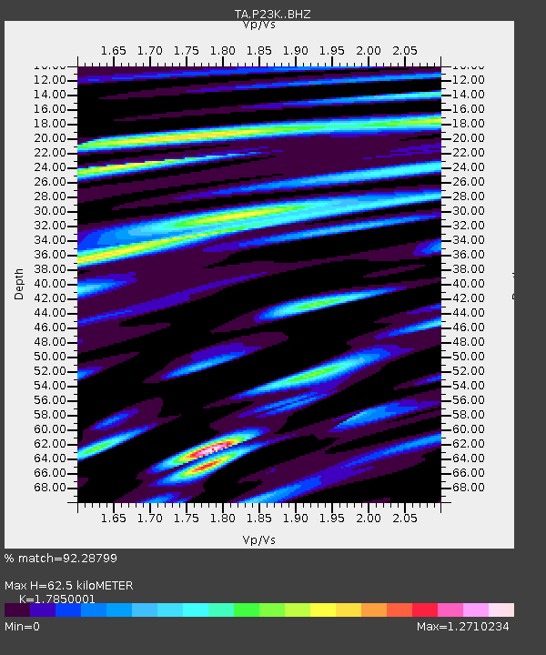
P23K Montague Island, AK, USA - Earthquake Result Viewer
| Earthquake location: |
Central Mexico |
| Earthquake latitude/longitude: |
18.6/-98.5 |
| Earthquake time(UTC): |
2017/09/19 (262) 18:14:38 GMT |
| Earthquake Depth: |
51 km |
| Earthquake Magnitude: |
7.1 Mww |
| Earthquake Catalog/Contributor: |
NEIC PDE/us |
|
| Network: |
TA USArray Transportable Network (new EarthScope stations) |
| Station: |
P23K Montague Island, AK, USA |
| Lat/Lon: |
60.00 N/147.40 W |
| Elevation: |
287 m |
|
| Distance: |
54.1 deg |
| Az: |
332.112 deg |
| Baz: |
117.998 deg |
| Ray Param: |
0.06555779 |
| Estimated Moho Depth: |
62.5 km |
| Estimated Crust Vp/Vs: |
1.79 |
| Assumed Crust Vp: |
5.989 km/s |
| Estimated Crust Vs: |
3.355 km/s |
| Estimated Crust Poisson's Ratio: |
0.27 |
|
| Radial Match: |
92.28799 % |
| Radial Bump: |
400 |
| Transverse Match: |
85.92596 % |
| Transverse Bump: |
400 |
| SOD ConfigId: |
13570011 |
| Insert Time: |
2019-04-28 19:46:45.604 +0000 |
| GWidth: |
2.5 |
| Max Bumps: |
400 |
| Tol: |
0.001 |
|

Signal To Noise
| Channel | StoN | STA | LTA |
| TA:P23K: :BHZ:20170919T18:23:27.224993Z | 33.855366 | 7.5273797E-6 | 2.2233934E-7 |
| TA:P23K: :BHN:20170919T18:23:27.224993Z | 4.5253363 | 2.2353704E-6 | 4.939678E-7 |
| TA:P23K: :BHE:20170919T18:23:27.224993Z | 10.19901 | 4.0153495E-6 | 3.9369993E-7 |
| Arrivals |
| Ps | 8.6 SECOND |
| PpPs | 28 SECOND |
| PsPs/PpSs | 36 SECOND |


