You are here: Home > Network List > TA - USArray Transportable Network (new EarthScope stations) Stations List
> Station R16K Pilot Point, AK, USA > Earthquake Result Viewer
R16K Pilot Point, AK, USA - Earthquake Result Viewer
| Earthquake location: |
Central Mexico |
| Earthquake latitude/longitude: |
18.6/-98.5 |
| Earthquake time(UTC): |
2017/09/19 (262) 18:14:38 GMT |
| Earthquake Depth: |
51 km |
| Earthquake Magnitude: |
7.1 Mww |
| Earthquake Catalog/Contributor: |
NEIC PDE/us |
|
| Network: |
TA USArray Transportable Network (new EarthScope stations) |
| Station: |
R16K Pilot Point, AK, USA |
| Lat/Lon: |
57.57 N/157.57 W |
| Elevation: |
38 m |
|
| Distance: |
58.1 deg |
| Az: |
326.989 deg |
| Baz: |
106.444 deg |
| Ray Param: |
0.062975846 |
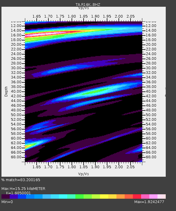
| Estimated Moho Depth: |
15.25 km |
| Estimated Crust Vp/Vs: |
1.69 |
| Assumed Crust Vp: |
6.1 km/s |
| Estimated Crust Vs: |
3.62 km/s |
| Estimated Crust Poisson's Ratio: |
0.23 |
|
| Radial Match: |
83.200165 % |
| Radial Bump: |
400 |
| Transverse Match: |
70.650894 % |
| Transverse Bump: |
400 |
| SOD ConfigId: |
13570011 |
| Insert Time: |
2019-04-28 19:46:56.167 +0000 |
| GWidth: |
2.5 |
| Max Bumps: |
400 |
| Tol: |
0.001 |
|

Signal To Noise
| Channel | StoN | STA | LTA |
| TA:R16K: :BHZ:20170919T18:23:55.599993Z | 3.8514783 | 8.851693E-6 | 2.2982583E-6 |
| TA:R16K: :BHN:20170919T18:23:55.599993Z | 0.8181606 | 1.4572307E-6 | 1.781106E-6 |
| TA:R16K: :BHE:20170919T18:23:55.599993Z | 2.2634158 | 3.859686E-6 | 1.7052482E-6 |
| Arrivals |
| Ps | 1.8 SECOND |
| PpPs | 6.4 SECOND |
| PsPs/PpSs | 8.2 SECOND |


