You are here: Home > Network List > TA - USArray Transportable Network (new EarthScope stations) Stations List
> Station R32K Eaglecrest, AK, USA > Earthquake Result Viewer
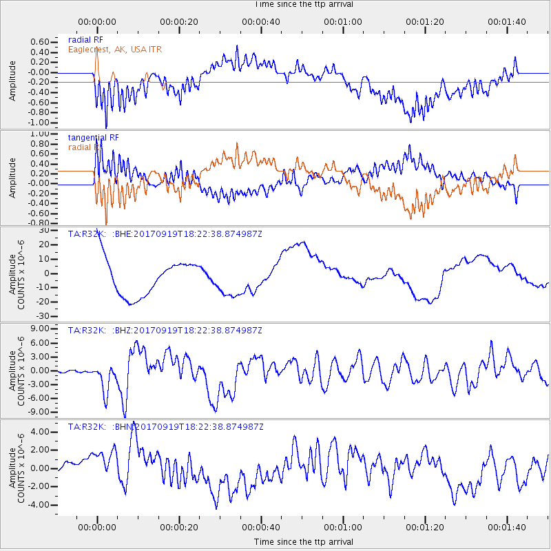
R32K Eaglecrest, AK, USA - Earthquake Result Viewer
*The percent match for this event was below the threshold and hence no stack was calculated.
| Earthquake location: |
Central Mexico |
| Earthquake latitude/longitude: |
18.6/-98.5 |
| Earthquake time(UTC): |
2017/09/19 (262) 18:14:38 GMT |
| Earthquake Depth: |
51 km |
| Earthquake Magnitude: |
7.1 Mww |
| Earthquake Catalog/Contributor: |
NEIC PDE/us |
|
| Network: |
TA USArray Transportable Network (new EarthScope stations) |
| Station: |
R32K Eaglecrest, AK, USA |
| Lat/Lon: |
58.27 N/134.52 W |
| Elevation: |
386 m |
|
| Distance: |
47.6 deg |
| Az: |
335.125 deg |
| Baz: |
130.958 deg |
| Ray Param: |
$rayparam |
*The percent match for this event was below the threshold and hence was not used in the summary stack. |
|
| Radial Match: |
57.46918 % |
| Radial Bump: |
400 |
| Transverse Match: |
54.15317 % |
| Transverse Bump: |
400 |
| SOD ConfigId: |
13570011 |
| Insert Time: |
2019-04-28 19:46:58.243 +0000 |
| GWidth: |
2.5 |
| Max Bumps: |
400 |
| Tol: |
0.001 |
|
Signal To Noise
| Channel | StoN | STA | LTA |
| TA:R32K: :BHZ:20170919T18:22:38.874987Z | 13.002622 | 3.1980007E-6 | 2.4595047E-7 |
| TA:R32K: :BHN:20170919T18:22:38.874987Z | 2.0544262 | 2.2248723E-6 | 1.0829654E-6 |
| TA:R32K: :BHE:20170919T18:22:38.874987Z | 0.9128165 | 1.1609459E-5 | 1.2718283E-5 |
| Arrivals |
| Ps | |
| PpPs | |
| PsPs/PpSs | |


