You are here: Home > Network List > UW - Pacific Northwest Regional Seismic Network Stations List
> Station HEBO Mt. Hebo, OR CREST BB SMO > Earthquake Result Viewer
HEBO Mt. Hebo, OR CREST BB SMO - Earthquake Result Viewer
| Earthquake location: |
Central Mexico |
| Earthquake latitude/longitude: |
18.6/-98.5 |
| Earthquake time(UTC): |
2017/09/19 (262) 18:14:38 GMT |
| Earthquake Depth: |
51 km |
| Earthquake Magnitude: |
7.1 Mww |
| Earthquake Catalog/Contributor: |
NEIC PDE/us |
|
| Network: |
UW Pacific Northwest Regional Seismic Network |
| Station: |
HEBO Mt. Hebo, OR CREST BB SMO |
| Lat/Lon: |
45.21 N/123.76 W |
| Elevation: |
875 m |
|
| Distance: |
33.9 deg |
| Az: |
327.246 deg |
| Baz: |
133.438 deg |
| Ray Param: |
0.07789006 |
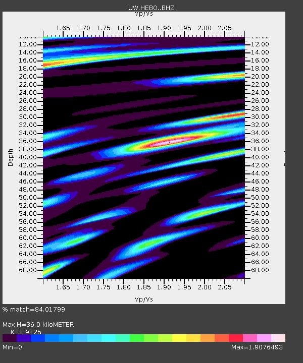
| Estimated Moho Depth: |
36.0 km |
| Estimated Crust Vp/Vs: |
1.91 |
| Assumed Crust Vp: |
6.566 km/s |
| Estimated Crust Vs: |
3.433 km/s |
| Estimated Crust Poisson's Ratio: |
0.31 |
|
| Radial Match: |
84.01799 % |
| Radial Bump: |
400 |
| Transverse Match: |
65.43646 % |
| Transverse Bump: |
400 |
| SOD ConfigId: |
13570011 |
| Insert Time: |
2019-04-28 19:47:37.819 +0000 |
| GWidth: |
2.5 |
| Max Bumps: |
400 |
| Tol: |
0.001 |
|
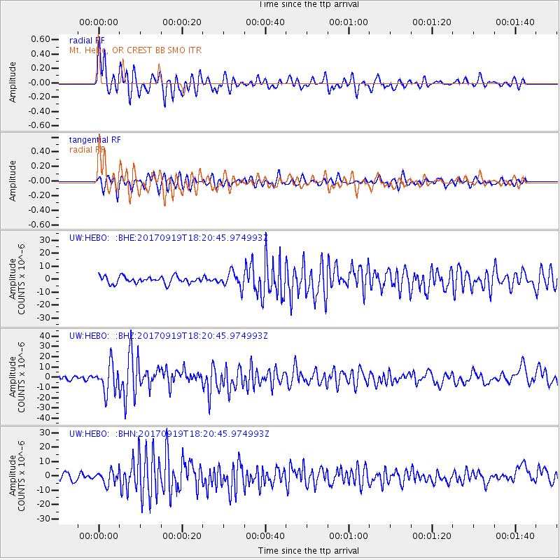
Signal To Noise
| Channel | StoN | STA | LTA |
| UW:HEBO: :BHZ:20170919T18:20:45.974993Z | 8.863275 | 1.372513E-5 | 1.5485394E-6 |
| UW:HEBO: :BHN:20170919T18:20:45.974993Z | 1.8886018 | 4.672009E-6 | 2.4737926E-6 |
| UW:HEBO: :BHE:20170919T18:20:45.974993Z | 2.2186904 | 5.9435583E-6 | 2.6788587E-6 |
| Arrivals |
| Ps | 5.4 SECOND |
| PpPs | 15 SECOND |
| PsPs/PpSs | 20 SECOND |


