You are here: Home > Network List > UW - Pacific Northwest Regional Seismic Network Stations List
> Station LRIV Port Angeles, WA, USA > Earthquake Result Viewer
LRIV Port Angeles, WA, USA - Earthquake Result Viewer
| Earthquake location: |
Central Mexico |
| Earthquake latitude/longitude: |
18.6/-98.5 |
| Earthquake time(UTC): |
2017/09/19 (262) 18:14:38 GMT |
| Earthquake Depth: |
51 km |
| Earthquake Magnitude: |
7.1 Mww |
| Earthquake Catalog/Contributor: |
NEIC PDE/us |
|
| Network: |
UW Pacific Northwest Regional Seismic Network |
| Station: |
LRIV Port Angeles, WA, USA |
| Lat/Lon: |
48.06 N/123.50 W |
| Elevation: |
294 m |
|
| Distance: |
35.8 deg |
| Az: |
330.98 deg |
| Baz: |
136.685 deg |
| Ray Param: |
0.07691083 |
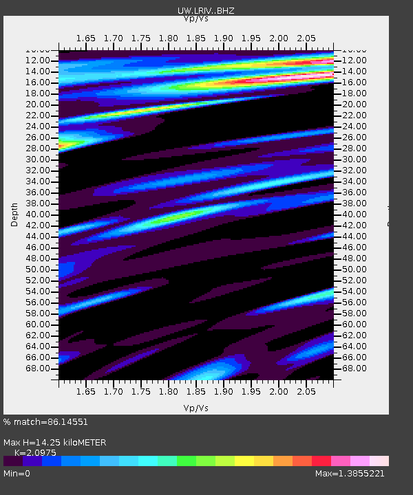
| Estimated Moho Depth: |
14.25 km |
| Estimated Crust Vp/Vs: |
2.10 |
| Assumed Crust Vp: |
6.566 km/s |
| Estimated Crust Vs: |
3.13 km/s |
| Estimated Crust Poisson's Ratio: |
0.35 |
|
| Radial Match: |
86.14551 % |
| Radial Bump: |
400 |
| Transverse Match: |
77.74433 % |
| Transverse Bump: |
400 |
| SOD ConfigId: |
13570011 |
| Insert Time: |
2019-04-28 19:47:44.022 +0000 |
| GWidth: |
2.5 |
| Max Bumps: |
400 |
| Tol: |
0.001 |
|

Signal To Noise
| Channel | StoN | STA | LTA |
| UW:LRIV: :BHZ:20170919T18:21:02.240007Z | 7.5732727 | 6.0194766E-6 | 7.948316E-7 |
| UW:LRIV: :BHN:20170919T18:21:02.240007Z | 3.6555626 | 3.5165708E-6 | 9.61978E-7 |
| UW:LRIV: :BHE:20170919T18:21:02.240007Z | 5.965517 | 2.9581254E-6 | 4.958707E-7 |
| Arrivals |
| Ps | 2.5 SECOND |
| PpPs | 6.3 SECOND |
| PsPs/PpSs | 8.8 SECOND |


