You are here: Home > Network List > TA - USArray Transportable Network (new EarthScope stations) Stations List
> Station L09A Wilkinson Ranch, McDermitt, NV, USA > Earthquake Result Viewer
L09A Wilkinson Ranch, McDermitt, NV, USA - Earthquake Result Viewer
| Earthquake location: |
Near Coast Of Peru |
| Earthquake latitude/longitude: |
-13.6/-76.6 |
| Earthquake time(UTC): |
2007/08/19 (231) 01:22:40 GMT |
| Earthquake Depth: |
26 km |
| Earthquake Magnitude: |
5.9 MB, 5.4 MS, 5.8 MW, 5.5 ML |
| Earthquake Catalog/Contributor: |
WHDF/NEIC |
|
| Network: |
TA USArray Transportable Network (new EarthScope stations) |
| Station: |
L09A Wilkinson Ranch, McDermitt, NV, USA |
| Lat/Lon: |
42.02 N/117.67 W |
| Elevation: |
1430 m |
|
| Distance: |
67.0 deg |
| Az: |
327.894 deg |
| Baz: |
136.097 deg |
| Ray Param: |
0.057184663 |
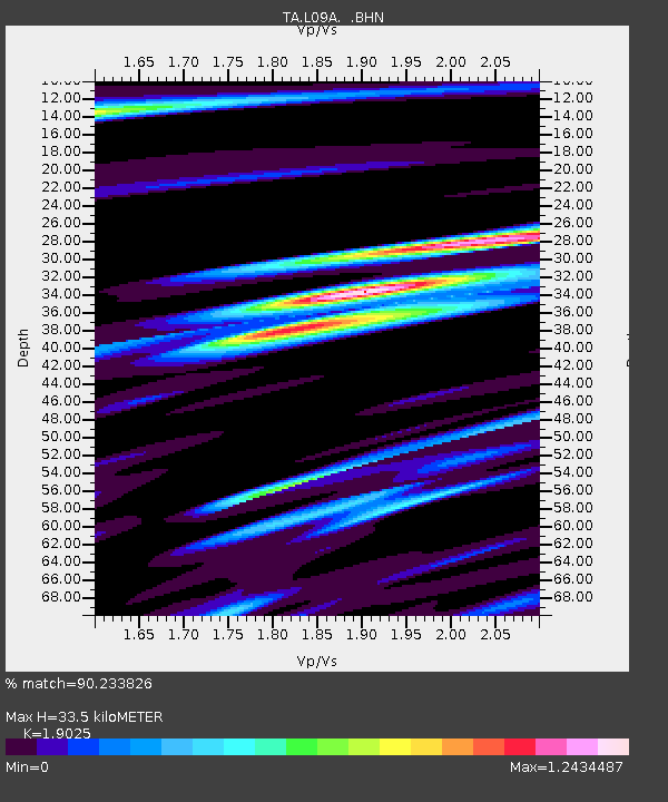
| Estimated Moho Depth: |
33.5 km |
| Estimated Crust Vp/Vs: |
1.90 |
| Assumed Crust Vp: |
6.291 km/s |
| Estimated Crust Vs: |
3.307 km/s |
| Estimated Crust Poisson's Ratio: |
0.31 |
|
| Radial Match: |
90.233826 % |
| Radial Bump: |
400 |
| Transverse Match: |
78.38978 % |
| Transverse Bump: |
400 |
| SOD ConfigId: |
2564 |
| Insert Time: |
2010-03-06 03:53:44.453 +0000 |
| GWidth: |
2.5 |
| Max Bumps: |
400 |
| Tol: |
0.001 |
|
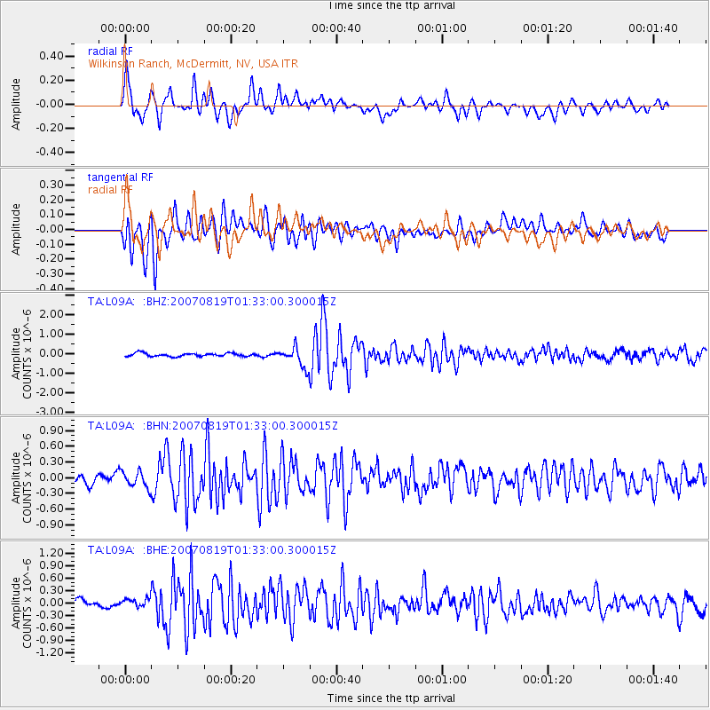
Signal To Noise
| Channel | StoN | STA | LTA |
| TA:L09A: :BHN:20070819T01:33:00.300015Z | 1.8888863 | 1.5175516E-7 | 8.034108E-8 |
| TA:L09A: :BHE:20070819T01:33:00.300015Z | 1.0540535 | 1.157258E-7 | 1.097912E-7 |
| TA:L09A: :BHZ:20070819T01:33:00.300015Z | 6.2822247 | 5.177411E-7 | 8.241366E-8 |
| Arrivals |
| Ps | 5.0 SECOND |
| PpPs | 15 SECOND |
| PsPs/PpSs | 20 SECOND |


