You are here: Home > Network List > TA - USArray Transportable Network (new EarthScope stations) Stations List
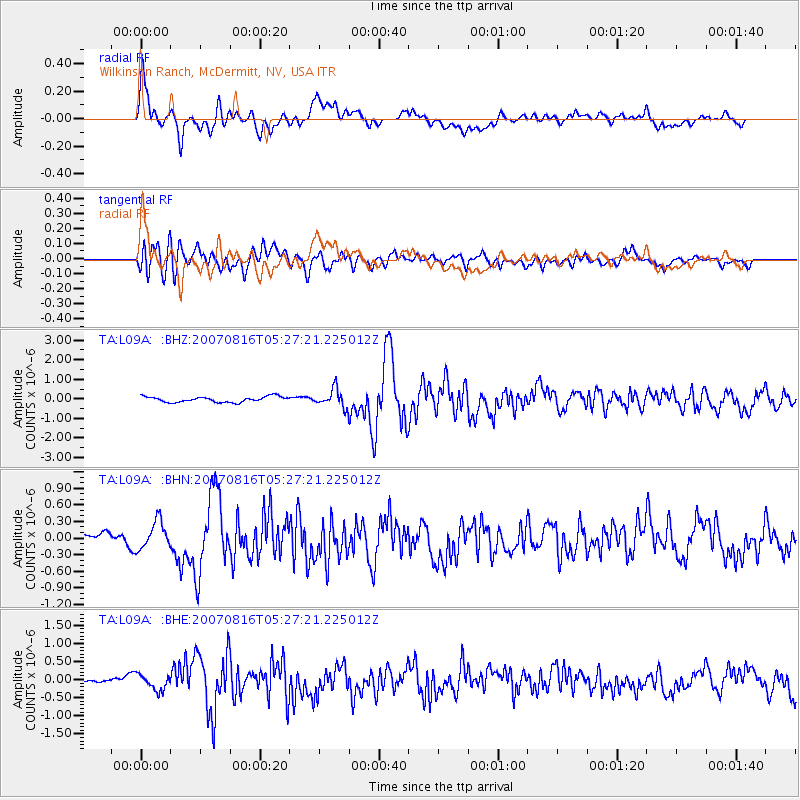
> Station L09A Wilkinson Ranch, McDermitt, NV, USA > Earthquake Result Viewer
L09A Wilkinson Ranch, McDermitt, NV, USA - Earthquake Result Viewer
| Earthquake location: |
Near Coast Of Peru |
| Earthquake latitude/longitude: |
-14.3/-76.1 |
| Earthquake time(UTC): |
2007/08/16 (228) 05:16:56 GMT |
| Earthquake Depth: |
23 km |
| Earthquake Magnitude: |
5.8 MB, 6.1 MS, 6.3 MW, 6.2 ML |
| Earthquake Catalog/Contributor: |
WHDF/NEIC |
|
| Network: |
TA USArray Transportable Network (new EarthScope stations) |
| Station: |
L09A Wilkinson Ranch, McDermitt, NV, USA |
| Lat/Lon: |
42.02 N/117.67 W |
| Elevation: |
1430 m |
|
| Distance: |
67.8 deg |
| Az: |
327.754 deg |
| Baz: |
136.037 deg |
| Ray Param: |
0.056667794 |
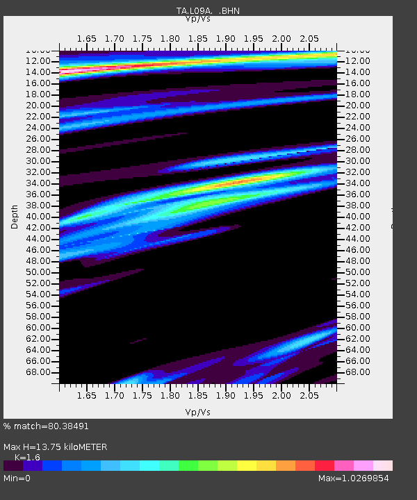
| Estimated Moho Depth: |
13.75 km |
| Estimated Crust Vp/Vs: |
1.60 |
| Assumed Crust Vp: |
6.291 km/s |
| Estimated Crust Vs: |
3.932 km/s |
| Estimated Crust Poisson's Ratio: |
0.18 |
|
| Radial Match: |
80.38491 % |
| Radial Bump: |
400 |
| Transverse Match: |
76.12122 % |
| Transverse Bump: |
400 |
| SOD ConfigId: |
2564 |
| Insert Time: |
2010-03-06 03:53:49.935 +0000 |
| GWidth: |
2.5 |
| Max Bumps: |
400 |
| Tol: |
0.001 |
|
Signal To Noise
| Channel | StoN | STA | LTA |
| TA:L09A: :BHN:20070816T05:27:21.225012Z | 1.2769114 | 2.5558387E-7 | 2.0015786E-7 |
| TA:L09A: :BHE:20070816T05:27:21.225012Z | 1.2714392 | 2.0816418E-7 | 1.6372327E-7 |
| TA:L09A: :BHZ:20070816T05:27:21.225012Z | 3.2939508 | 4.6283319E-7 | 1.4051005E-7 |
| Arrivals |
| Ps | 1.4 SECOND |
| PpPs | 5.5 SECOND |
| PsPs/PpSs | 6.8 SECOND |


