You are here: Home > Network List > TA - USArray Transportable Network (new EarthScope stations) Stations List
> Station L09A Wilkinson Ranch, McDermitt, NV, USA > Earthquake Result Viewer
L09A Wilkinson Ranch, McDermitt, NV, USA - Earthquake Result Viewer

| Earthquake location: |
Andreanof Islands, Aleutian Is. |
| Earthquake latitude/longitude: |
51.8/-176.3 |
| Earthquake time(UTC): |
2007/07/13 (194) 21:54:43 GMT |
| Earthquake Depth: |
35 km |
| Earthquake Magnitude: |
5.7 MB, 5.6 MS, 6.0 MW, 5.9 MW |
| Earthquake Catalog/Contributor: |
WHDF/NEIC |
|
| Network: |
TA USArray Transportable Network (new EarthScope stations) |
| Station: |
L09A Wilkinson Ranch, McDermitt, NV, USA |
| Lat/Lon: |
42.02 N/117.67 W |
| Elevation: |
1430 m |
|
| Distance: |
40.2 deg |
| Az: |
80.24 deg |
| Baz: |
304.855 deg |
| Ray Param: |
0.074466676 |
| Estimated Moho Depth: |
44.5 km |
| Estimated Crust Vp/Vs: |
1.68 |
| Assumed Crust Vp: |
6.291 km/s |
| Estimated Crust Vs: |
3.75 km/s |
| Estimated Crust Poisson's Ratio: |
0.22 |
|
| Radial Match: |
86.363945 % |
| Radial Bump: |
400 |
| Transverse Match: |
80.47836 % |
| Transverse Bump: |
400 |
| SOD ConfigId: |
2564 |
| Insert Time: |
2010-03-06 03:54:09.915 +0000 |
| GWidth: |
2.5 |
| Max Bumps: |
400 |
| Tol: |
0.001 |
|
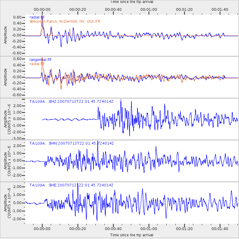
Signal To Noise
| Channel | StoN | STA | LTA |
| TA:L09A: :BHN:20070713T22:01:45.724014Z | 3.503924 | 3.0448209E-7 | 8.689746E-8 |
| TA:L09A: :BHE:20070713T22:01:45.724014Z | 3.1041367 | 2.6568722E-7 | 8.5591346E-8 |
| TA:L09A: :BHZ:20070713T22:01:45.724014Z | 9.865121 | 7.7074947E-7 | 7.812874E-8 |
| Arrivals |
| Ps | 5.1 SECOND |
| PpPs | 18 SECOND |
| PsPs/PpSs | 23 SECOND |


