You are here: Home > Network List > TA - USArray Transportable Network (new EarthScope stations) Stations List
> Station L09A Wilkinson Ranch, McDermitt, NV, USA > Earthquake Result Viewer
L09A Wilkinson Ranch, McDermitt, NV, USA - Earthquake Result Viewer
| Earthquake location: |
Near Coast Of Guatemala |
| Earthquake latitude/longitude: |
13.8/-90.8 |
| Earthquake time(UTC): |
2007/06/08 (159) 13:32:00 GMT |
| Earthquake Depth: |
48 km |
| Earthquake Magnitude: |
5.5 MB, 5.4 MS, 5.8 MW, 5.8 MW |
| Earthquake Catalog/Contributor: |
WHDF/NEIC |
|
| Network: |
TA USArray Transportable Network (new EarthScope stations) |
| Station: |
L09A Wilkinson Ranch, McDermitt, NV, USA |
| Lat/Lon: |
42.02 N/117.67 W |
| Elevation: |
1430 m |
|
| Distance: |
36.5 deg |
| Az: |
325.465 deg |
| Baz: |
132.352 deg |
| Ray Param: |
0.07653513 |
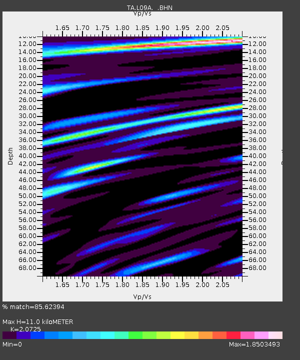
| Estimated Moho Depth: |
11.0 km |
| Estimated Crust Vp/Vs: |
2.07 |
| Assumed Crust Vp: |
6.291 km/s |
| Estimated Crust Vs: |
3.036 km/s |
| Estimated Crust Poisson's Ratio: |
0.35 |
|
| Radial Match: |
85.62394 % |
| Radial Bump: |
400 |
| Transverse Match: |
68.35013 % |
| Transverse Bump: |
400 |
| SOD ConfigId: |
2564 |
| Insert Time: |
2010-03-06 03:54:21.194 +0000 |
| GWidth: |
2.5 |
| Max Bumps: |
400 |
| Tol: |
0.001 |
|

Signal To Noise
| Channel | StoN | STA | LTA |
| TA:L09A: :BHN:20070608T13:38:31.025005Z | 3.835037 | 2.2132056E-7 | 5.771015E-8 |
| TA:L09A: :BHE:20070608T13:38:31.025005Z | 6.9158707 | 4.155424E-7 | 6.0085334E-8 |
| TA:L09A: :BHZ:20070608T13:38:31.025005Z | 10.972552 | 8.350174E-7 | 7.610056E-8 |
| Arrivals |
| Ps | 2.0 SECOND |
| PpPs | 5.1 SECOND |
| PsPs/PpSs | 7.0 SECOND |


