You are here: Home > Network List > TA - USArray Transportable Network (new EarthScope stations) Stations List
> Station L09A Wilkinson Ranch, McDermitt, NV, USA > Earthquake Result Viewer
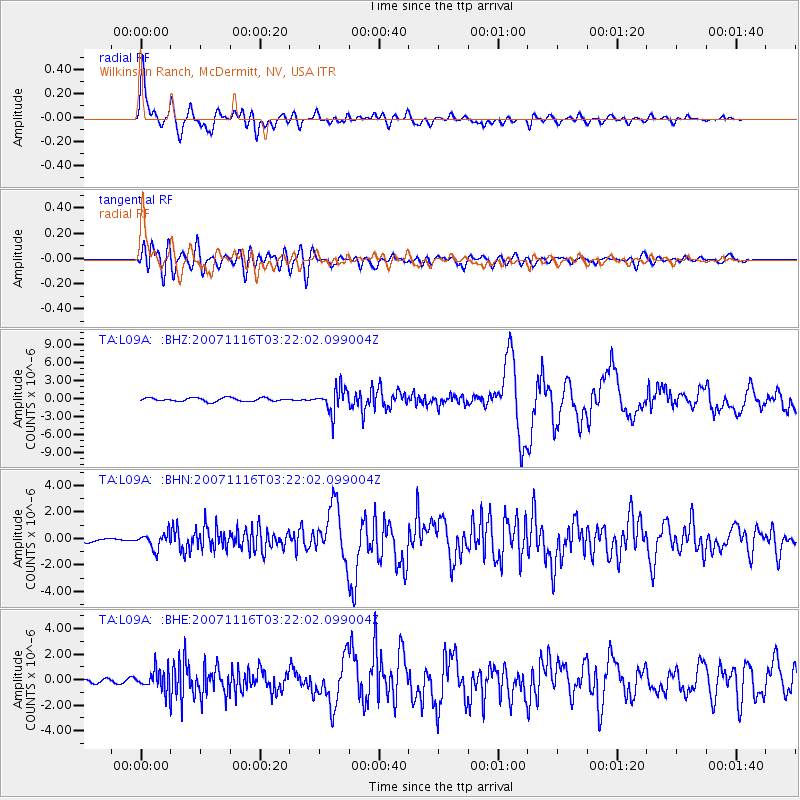
L09A Wilkinson Ranch, McDermitt, NV, USA - Earthquake Result Viewer

| Earthquake location: |
Peru-Ecuador Border Region |
| Earthquake latitude/longitude: |
-2.3/-77.8 |
| Earthquake time(UTC): |
2007/11/16 (320) 03:13:00 GMT |
| Earthquake Depth: |
123 km |
| Earthquake Magnitude: |
6.3 MB, 6.8 MW, 6.7 MW |
| Earthquake Catalog/Contributor: |
WHDF/NEIC |
|
| Network: |
TA USArray Transportable Network (new EarthScope stations) |
| Station: |
L09A Wilkinson Ranch, McDermitt, NV, USA |
| Lat/Lon: |
42.02 N/117.67 W |
| Elevation: |
1430 m |
|
| Distance: |
57.0 deg |
| Az: |
325.301 deg |
| Baz: |
130.24 deg |
| Ray Param: |
0.06341859 |
| Estimated Moho Depth: |
40.75 km |
| Estimated Crust Vp/Vs: |
1.77 |
| Assumed Crust Vp: |
6.291 km/s |
| Estimated Crust Vs: |
3.544 km/s |
| Estimated Crust Poisson's Ratio: |
0.27 |
|
| Radial Match: |
94.66386 % |
| Radial Bump: |
400 |
| Transverse Match: |
79.6527 % |
| Transverse Bump: |
400 |
| SOD ConfigId: |
2564 |
| Insert Time: |
2010-03-06 03:54:39.298 +0000 |
| GWidth: |
2.5 |
| Max Bumps: |
400 |
| Tol: |
0.001 |
|
Signal To Noise
| Channel | StoN | STA | LTA |
| TA:L09A: :BHN:20071116T03:22:02.099004Z | 2.569509 | 5.828699E-7 | 2.2684097E-7 |
| TA:L09A: :BHE:20071116T03:22:02.099004Z | 3.2230422 | 8.3001E-7 | 2.5752377E-7 |
| TA:L09A: :BHZ:20071116T03:22:02.099004Z | 6.9195313 | 2.0607315E-6 | 2.9781373E-7 |
| Arrivals |
| Ps | 5.3 SECOND |
| PpPs | 17 SECOND |
| PsPs/PpSs | 22 SECOND |


