You are here: Home > Network List > TA - USArray Transportable Network (new EarthScope stations) Stations List
> Station 435B Jarrell, TX, USA > Earthquake Result Viewer
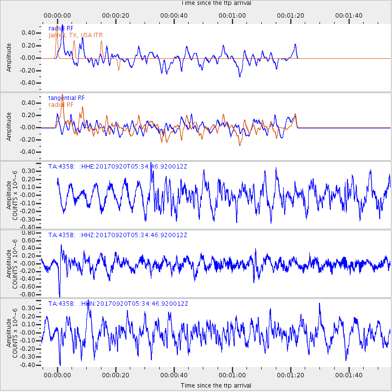
435B Jarrell, TX, USA - Earthquake Result Viewer
*The percent match for this event was below the threshold and hence no stack was calculated.
| Earthquake location: |
Southern Peru |
| Earthquake latitude/longitude: |
-16.3/-71.3 |
| Earthquake time(UTC): |
2017/09/20 (263) 05:26:08 GMT |
| Earthquake Depth: |
93 km |
| Earthquake Magnitude: |
5.3 Mww |
| Earthquake Catalog/Contributor: |
NEIC PDE/us |
|
| Network: |
TA USArray Transportable Network (new EarthScope stations) |
| Station: |
435B Jarrell, TX, USA |
| Lat/Lon: |
30.78 N/97.58 W |
| Elevation: |
248 m |
|
| Distance: |
53.2 deg |
| Az: |
331.585 deg |
| Baz: |
147.925 deg |
| Ray Param: |
$rayparam |
*The percent match for this event was below the threshold and hence was not used in the summary stack. |
|
| Radial Match: |
55.703247 % |
| Radial Bump: |
400 |
| Transverse Match: |
55.798923 % |
| Transverse Bump: |
400 |
| SOD ConfigId: |
13570011 |
| Insert Time: |
2019-04-28 19:55:36.921 +0000 |
| GWidth: |
2.5 |
| Max Bumps: |
400 |
| Tol: |
0.001 |
|
Signal To Noise
| Channel | StoN | STA | LTA |
| TA:435B: :HHZ:20170920T05:34:46.920012Z | 2.2735097 | 2.8118743E-7 | 1.2367988E-7 |
| TA:435B: :HHN:20170920T05:34:46.920012Z | 1.7147042 | 1.382263E-7 | 8.0612324E-8 |
| TA:435B: :HHE:20170920T05:34:46.920012Z | 1.7146847 | 1.8039165E-7 | 1.0520397E-7 |
| Arrivals |
| Ps | |
| PpPs | |
| PsPs/PpSs | |


