You are here: Home > Network List > TA - USArray Transportable Network (new EarthScope stations) Stations List
> Station L09A Wilkinson Ranch, McDermitt, NV, USA > Earthquake Result Viewer
L09A Wilkinson Ranch, McDermitt, NV, USA - Earthquake Result Viewer
| Earthquake location: |
New Britain Region, P.N.G. |
| Earthquake latitude/longitude: |
-5.9/151.0 |
| Earthquake time(UTC): |
2006/10/17 (290) 01:25:12 GMT |
| Earthquake Depth: |
32 km |
| Earthquake Magnitude: |
6.4 MB, 6.9 MS, 6.7 MW, 6.6 MW |
| Earthquake Catalog/Contributor: |
WHDF/NEIC |
|
| Network: |
TA USArray Transportable Network (new EarthScope stations) |
| Station: |
L09A Wilkinson Ranch, McDermitt, NV, USA |
| Lat/Lon: |
42.02 N/117.67 W |
| Elevation: |
1430 m |
|
| Distance: |
94.9 deg |
| Az: |
48.389 deg |
| Baz: |
266.536 deg |
| Ray Param: |
0.04091224 |
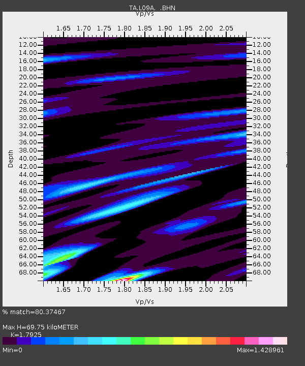
| Estimated Moho Depth: |
69.75 km |
| Estimated Crust Vp/Vs: |
1.79 |
| Assumed Crust Vp: |
6.291 km/s |
| Estimated Crust Vs: |
3.51 km/s |
| Estimated Crust Poisson's Ratio: |
0.27 |
|
| Radial Match: |
80.37467 % |
| Radial Bump: |
400 |
| Transverse Match: |
85.02908 % |
| Transverse Bump: |
400 |
| SOD ConfigId: |
2665 |
| Insert Time: |
2010-03-06 03:55:04.679 +0000 |
| GWidth: |
2.5 |
| Max Bumps: |
400 |
| Tol: |
0.001 |
|
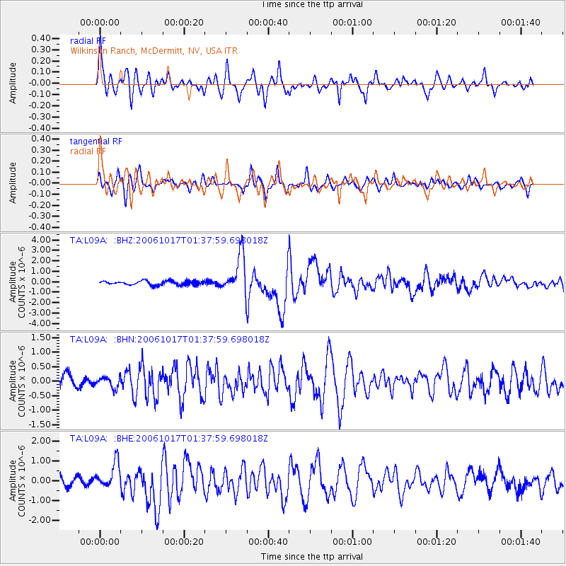
Signal To Noise
| Channel | StoN | STA | LTA |
| TA:L09A: :BHN:20061017T01:37:59.698018Z | 0.906959 | 1.8686062E-7 | 2.0602984E-7 |
| TA:L09A: :BHE:20061017T01:37:59.698018Z | 2.4110296 | 6.767689E-7 | 2.8069704E-7 |
| TA:L09A: :BHZ:20061017T01:37:59.698018Z | 9.722735 | 1.961358E-6 | 2.0172904E-7 |
| Arrivals |
| Ps | 9.0 SECOND |
| PpPs | 30 SECOND |
| PsPs/PpSs | 39 SECOND |


