You are here: Home > Network List > TA - USArray Transportable Network (new EarthScope stations) Stations List
> Station Q24A Divide, CO, USA > Earthquake Result Viewer
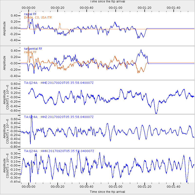
Q24A Divide, CO, USA - Earthquake Result Viewer
*The percent match for this event was below the threshold and hence no stack was calculated.
| Earthquake location: |
Southern Peru |
| Earthquake latitude/longitude: |
-16.3/-71.3 |
| Earthquake time(UTC): |
2017/09/20 (263) 05:26:08 GMT |
| Earthquake Depth: |
93 km |
| Earthquake Magnitude: |
5.3 Mww |
| Earthquake Catalog/Contributor: |
NEIC PDE/us |
|
| Network: |
TA USArray Transportable Network (new EarthScope stations) |
| Station: |
Q24A Divide, CO, USA |
| Lat/Lon: |
38.96 N/105.15 W |
| Elevation: |
2775 m |
|
| Distance: |
63.4 deg |
| Az: |
330.962 deg |
| Baz: |
143.275 deg |
| Ray Param: |
$rayparam |
*The percent match for this event was below the threshold and hence was not used in the summary stack. |
|
| Radial Match: |
44.016624 % |
| Radial Bump: |
400 |
| Transverse Match: |
41.52371 % |
| Transverse Bump: |
400 |
| SOD ConfigId: |
13570011 |
| Insert Time: |
2019-04-28 19:55:55.274 +0000 |
| GWidth: |
2.5 |
| Max Bumps: |
400 |
| Tol: |
0.001 |
|
Signal To Noise
| Channel | StoN | STA | LTA |
| TA:Q24A: :HHZ:20170920T05:35:58.040007Z | 2.0933363 | 3.3859484E-7 | 1.617489E-7 |
| TA:Q24A: :HHN:20170920T05:35:58.040007Z | 1.060871 | 1.4943163E-7 | 1.408575E-7 |
| TA:Q24A: :HHE:20170920T05:35:58.040007Z | 0.73040044 | 1.4114403E-7 | 1.9324197E-7 |
| Arrivals |
| Ps | |
| PpPs | |
| PsPs/PpSs | |


