You are here: Home > Network List > TA - USArray Transportable Network (new EarthScope stations) Stations List
> Station R31K City Hall, Gustavus, AK, USA > Earthquake Result Viewer
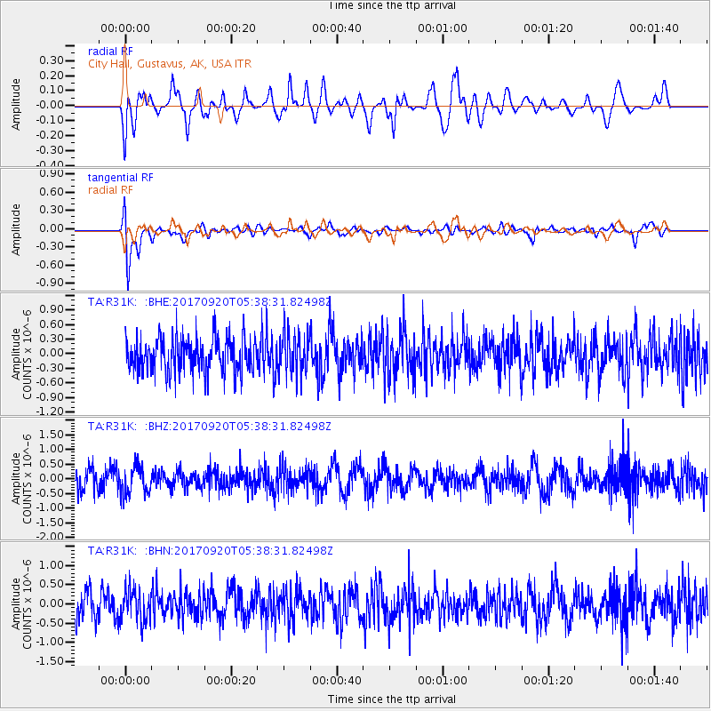
R31K City Hall, Gustavus, AK, USA - Earthquake Result Viewer
*The percent match for this event was below the threshold and hence no stack was calculated.
| Earthquake location: |
Southern Peru |
| Earthquake latitude/longitude: |
-16.3/-71.3 |
| Earthquake time(UTC): |
2017/09/20 (263) 05:26:08 GMT |
| Earthquake Depth: |
93 km |
| Earthquake Magnitude: |
5.3 Mww |
| Earthquake Catalog/Contributor: |
NEIC PDE/us |
|
| Network: |
TA USArray Transportable Network (new EarthScope stations) |
| Station: |
R31K City Hall, Gustavus, AK, USA |
| Lat/Lon: |
58.41 N/135.74 W |
| Elevation: |
15 m |
|
| Distance: |
91.1 deg |
| Az: |
331.65 deg |
| Baz: |
119.949 deg |
| Ray Param: |
$rayparam |
*The percent match for this event was below the threshold and hence was not used in the summary stack. |
|
| Radial Match: |
57.489223 % |
| Radial Bump: |
400 |
| Transverse Match: |
69.11105 % |
| Transverse Bump: |
400 |
| SOD ConfigId: |
13570011 |
| Insert Time: |
2019-04-28 19:55:55.787 +0000 |
| GWidth: |
2.5 |
| Max Bumps: |
400 |
| Tol: |
0.001 |
|
Signal To Noise
| Channel | StoN | STA | LTA |
| TA:R31K: :BHZ:20170920T05:38:31.82498Z | 1.4374608 | 4.857041E-7 | 3.3789036E-7 |
| TA:R31K: :BHN:20170920T05:38:31.82498Z | 1.1751167 | 4.173478E-7 | 3.5515433E-7 |
| TA:R31K: :BHE:20170920T05:38:31.82498Z | 1.1685406 | 4.0855326E-7 | 3.4962696E-7 |
| Arrivals |
| Ps | |
| PpPs | |
| PsPs/PpSs | |


