You are here: Home > Network List > UW - Pacific Northwest Regional Seismic Network Stations List
> Station MRBL Marblemount, WA, USA > Earthquake Result Viewer
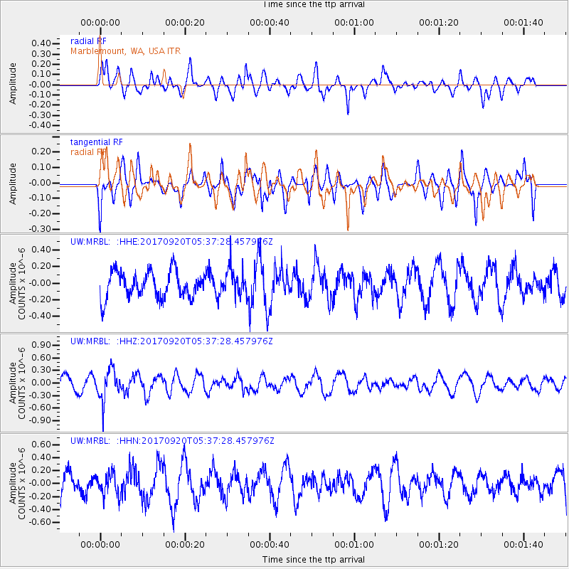
MRBL Marblemount, WA, USA - Earthquake Result Viewer
*The percent match for this event was below the threshold and hence no stack was calculated.
| Earthquake location: |
Southern Peru |
| Earthquake latitude/longitude: |
-16.3/-71.3 |
| Earthquake time(UTC): |
2017/09/20 (263) 05:26:08 GMT |
| Earthquake Depth: |
93 km |
| Earthquake Magnitude: |
5.3 Mww |
| Earthquake Catalog/Contributor: |
NEIC PDE/us |
|
| Network: |
UW Pacific Northwest Regional Seismic Network |
| Station: |
MRBL Marblemount, WA, USA |
| Lat/Lon: |
48.52 N/121.48 W |
| Elevation: |
75 m |
|
| Distance: |
78.4 deg |
| Az: |
328.586 deg |
| Baz: |
131.157 deg |
| Ray Param: |
$rayparam |
*The percent match for this event was below the threshold and hence was not used in the summary stack. |
|
| Radial Match: |
44.111076 % |
| Radial Bump: |
400 |
| Transverse Match: |
45.078056 % |
| Transverse Bump: |
400 |
| SOD ConfigId: |
13570011 |
| Insert Time: |
2019-04-28 19:56:41.987 +0000 |
| GWidth: |
2.5 |
| Max Bumps: |
400 |
| Tol: |
0.001 |
|
Signal To Noise
| Channel | StoN | STA | LTA |
| UW:MRBL: :HHZ:20170920T05:37:28.457976Z | 2.1370816 | 3.608112E-7 | 1.6883362E-7 |
| UW:MRBL: :HHN:20170920T05:37:28.457976Z | 0.6383993 | 1.7036723E-7 | 2.6686624E-7 |
| UW:MRBL: :HHE:20170920T05:37:28.457976Z | 1.0424562 | 1.6368746E-7 | 1.5702095E-7 |
| Arrivals |
| Ps | |
| PpPs | |
| PsPs/PpSs | |


