You are here: Home > Network List > AK - Alaska Regional Network Stations List
> Station FID Fidalgo > Earthquake Result Viewer
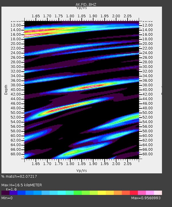
FID Fidalgo - Earthquake Result Viewer
| Earthquake location: |
Taiwan |
| Earthquake latitude/longitude: |
23.3/121.8 |
| Earthquake time(UTC): |
2017/09/20 (263) 14:29:56 GMT |
| Earthquake Depth: |
22 km |
| Earthquake Magnitude: |
5.3 Mww |
| Earthquake Catalog/Contributor: |
NEIC PDE/us |
|
| Network: |
AK Alaska Regional Network |
| Station: |
FID Fidalgo |
| Lat/Lon: |
60.73 N/146.60 W |
| Elevation: |
488 m |
|
| Distance: |
70.8 deg |
| Az: |
31.352 deg |
| Baz: |
283.24 deg |
| Ray Param: |
0.054742005 |
| Estimated Moho Depth: |
16.5 km |
| Estimated Crust Vp/Vs: |
1.60 |
| Assumed Crust Vp: |
6.566 km/s |
| Estimated Crust Vs: |
4.104 km/s |
| Estimated Crust Poisson's Ratio: |
0.18 |
|
| Radial Match: |
82.07217 % |
| Radial Bump: |
400 |
| Transverse Match: |
73.53125 % |
| Transverse Bump: |
400 |
| SOD ConfigId: |
13570011 |
| Insert Time: |
2019-04-28 19:58:09.657 +0000 |
| GWidth: |
2.5 |
| Max Bumps: |
400 |
| Tol: |
0.001 |
|

Signal To Noise
| Channel | StoN | STA | LTA |
| AK:FID: :BHZ:20170920T14:40:39.92802Z | 8.934585 | 9.832784E-7 | 1.1005306E-7 |
| AK:FID: :BHN:20170920T14:40:39.92802Z | 2.4131842 | 2.3804499E-7 | 9.8643525E-8 |
| AK:FID: :BHE:20170920T14:40:39.92802Z | 6.695669 | 5.195249E-7 | 7.759118E-8 |
| Arrivals |
| Ps | 1.6 SECOND |
| PpPs | 6.3 SECOND |
| PsPs/PpSs | 7.8 SECOND |


