You are here: Home > Network List > II - Global Seismograph Network (GSN - IRIS/IDA) Stations List
> Station WRAB Tennant Creek, NT, Australia > Earthquake Result Viewer
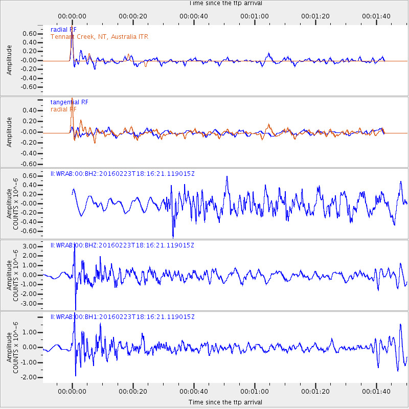
WRAB Tennant Creek, NT, Australia - Earthquake Result Viewer
*The percent match for this event was below the threshold and hence no stack was calculated.
| Earthquake location: |
South Of Australia |
| Earthquake latitude/longitude: |
-63.1/144.8 |
| Earthquake time(UTC): |
2016/02/23 (054) 18:08:46 GMT |
| Earthquake Depth: |
7.7 km |
| Earthquake Magnitude: |
5.9 MB |
| Earthquake Catalog/Contributor: |
NEIC PDE/NEIC COMCAT |
|
| Network: |
II Global Seismograph Network (GSN - IRIS/IDA) |
| Station: |
WRAB Tennant Creek, NT, Australia |
| Lat/Lon: |
19.93 S/134.36 E |
| Elevation: |
366 m |
|
| Distance: |
43.8 deg |
| Az: |
345.736 deg |
| Baz: |
173.165 deg |
| Ray Param: |
$rayparam |
*The percent match for this event was below the threshold and hence was not used in the summary stack. |
|
| Radial Match: |
67.0216 % |
| Radial Bump: |
400 |
| Transverse Match: |
67.02651 % |
| Transverse Bump: |
400 |
| SOD ConfigId: |
1427151 |
| Insert Time: |
2016-03-08 18:31:45.567 +0000 |
| GWidth: |
2.5 |
| Max Bumps: |
400 |
| Tol: |
0.001 |
|
Signal To Noise
| Channel | StoN | STA | LTA |
| II:WRAB:00:BHZ:20160223T18:16:21.119015Z | 7.0510507 | 1.185839E-6 | 1.6817906E-7 |
| II:WRAB:00:BH1:20160223T18:16:21.119015Z | 4.8054733 | 8.051332E-7 | 1.6754502E-7 |
| II:WRAB:00:BH2:20160223T18:16:21.119015Z | 1.903443 | 2.394309E-7 | 1.2578833E-7 |
| Arrivals |
| Ps | |
| PpPs | |
| PsPs/PpSs | |


