You are here: Home > Network List > TA - USArray Transportable Network (new EarthScope stations) Stations List
> Station N10A Dunphy, NV, USA > Earthquake Result Viewer
N10A Dunphy, NV, USA - Earthquake Result Viewer
| Earthquake location: |
Solomon Islands |
| Earthquake latitude/longitude: |
-10.9/162.1 |
| Earthquake time(UTC): |
2007/11/27 (331) 11:49:58 GMT |
| Earthquake Depth: |
16 km |
| Earthquake Magnitude: |
5.9 MB, 6.7 MS, 6.6 MW, 6.4 MW |
| Earthquake Catalog/Contributor: |
WHDF/NEIC |
|
| Network: |
TA USArray Transportable Network (new EarthScope stations) |
| Station: |
N10A Dunphy, NV, USA |
| Lat/Lon: |
40.72 N/116.51 W |
| Elevation: |
1392 m |
|
| Distance: |
90.6 deg |
| Az: |
48.717 deg |
| Baz: |
256.142 deg |
| Ray Param: |
0.04166161 |
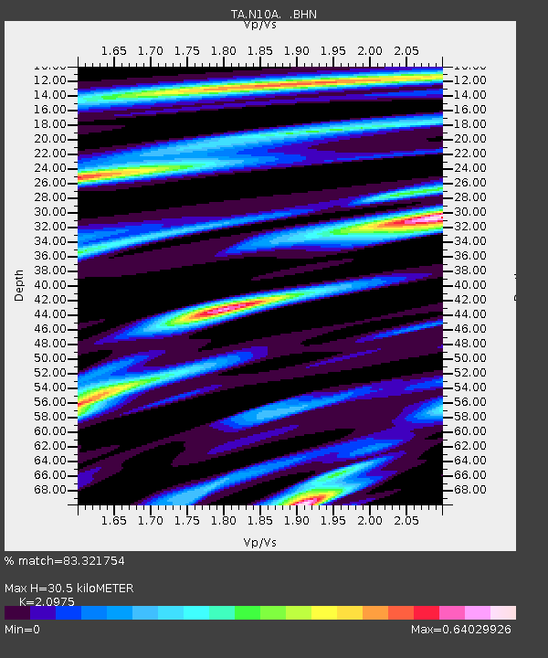
| Estimated Moho Depth: |
30.5 km |
| Estimated Crust Vp/Vs: |
2.10 |
| Assumed Crust Vp: |
6.276 km/s |
| Estimated Crust Vs: |
2.992 km/s |
| Estimated Crust Poisson's Ratio: |
0.35 |
|
| Radial Match: |
83.321754 % |
| Radial Bump: |
400 |
| Transverse Match: |
68.06429 % |
| Transverse Bump: |
400 |
| SOD ConfigId: |
2564 |
| Insert Time: |
2010-03-06 03:55:56.265 +0000 |
| GWidth: |
2.5 |
| Max Bumps: |
400 |
| Tol: |
0.001 |
|

Signal To Noise
| Channel | StoN | STA | LTA |
| TA:N10A: :BHN:20071127T12:02:27.775015Z | 1.7513605 | 2.2545167E-7 | 1.2872944E-7 |
| TA:N10A: :BHE:20071127T12:02:27.775015Z | 2.7297814 | 5.334185E-7 | 1.9540703E-7 |
| TA:N10A: :BHZ:20071127T12:02:27.775015Z | 9.701635 | 1.2414738E-6 | 1.2796541E-7 |
| Arrivals |
| Ps | 5.4 SECOND |
| PpPs | 15 SECOND |
| PsPs/PpSs | 20 SECOND |


