You are here: Home > Network List > TA - USArray Transportable Network (new EarthScope stations) Stations List
> Station N10A Dunphy, NV, USA > Earthquake Result Viewer
N10A Dunphy, NV, USA - Earthquake Result Viewer
| Earthquake location: |
Fiji Islands Region |
| Earthquake latitude/longitude: |
-20.7/-177.4 |
| Earthquake time(UTC): |
2007/10/08 (281) 18:37:53 GMT |
| Earthquake Depth: |
338 km |
| Earthquake Magnitude: |
5.6 MB, 5.7 MW, 5.6 MW |
| Earthquake Catalog/Contributor: |
WHDF/NEIC |
|
| Network: |
TA USArray Transportable Network (new EarthScope stations) |
| Station: |
N10A Dunphy, NV, USA |
| Lat/Lon: |
40.72 N/116.51 W |
| Elevation: |
1392 m |
|
| Distance: |
83.2 deg |
| Az: |
41.969 deg |
| Baz: |
235.454 deg |
| Ray Param: |
0.045448415 |
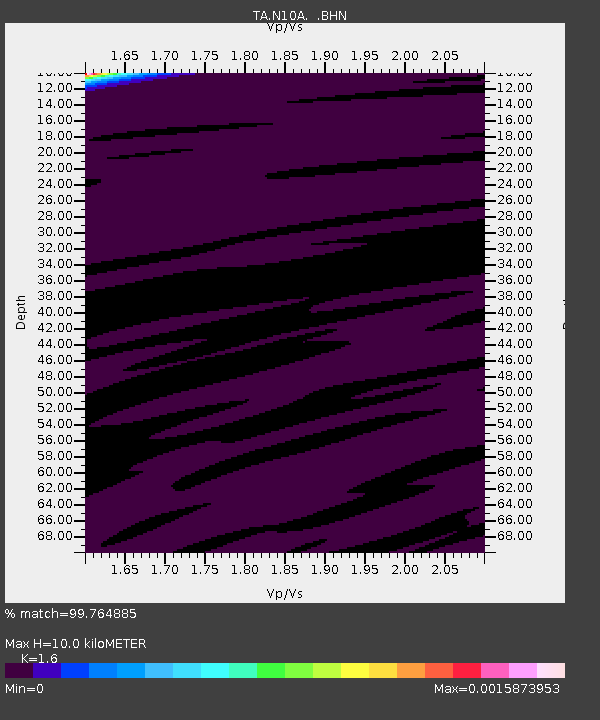
| Estimated Moho Depth: |
10.0 km |
| Estimated Crust Vp/Vs: |
1.60 |
| Assumed Crust Vp: |
6.276 km/s |
| Estimated Crust Vs: |
3.922 km/s |
| Estimated Crust Poisson's Ratio: |
0.18 |
|
| Radial Match: |
99.764885 % |
| Radial Bump: |
24 |
| Transverse Match: |
96.78324 % |
| Transverse Bump: |
73 |
| SOD ConfigId: |
2564 |
| Insert Time: |
2010-03-06 03:56:23.150 +0000 |
| GWidth: |
2.5 |
| Max Bumps: |
400 |
| Tol: |
0.001 |
|
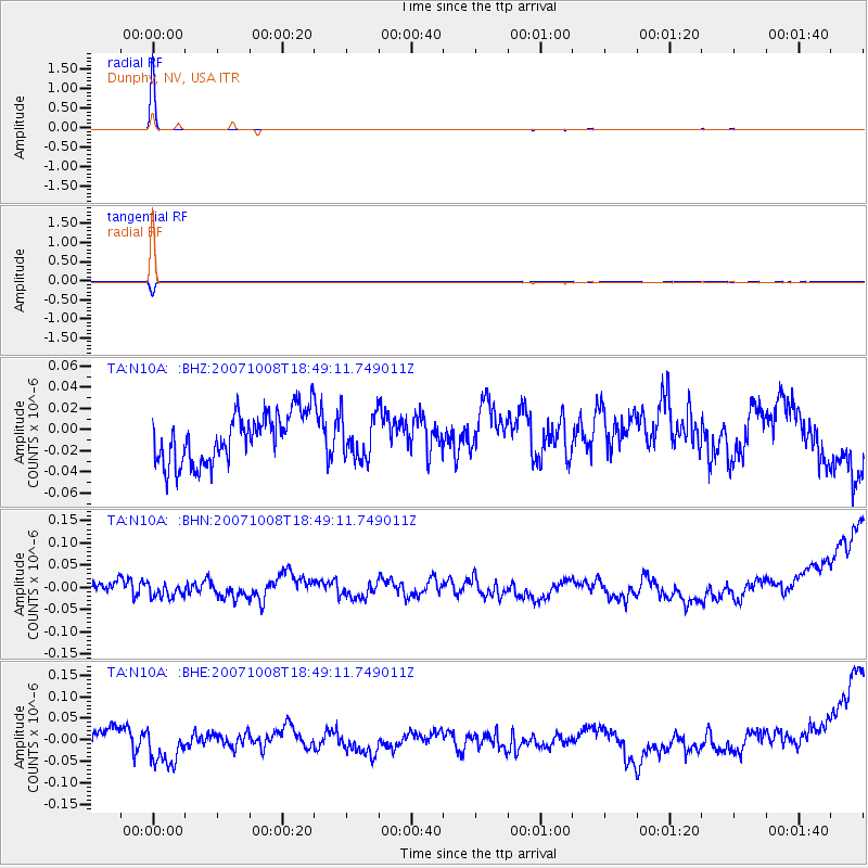
Signal To Noise
| Channel | StoN | STA | LTA |
| TA:N10A: :BHN:20071008T18:49:11.749011Z | 0.7774395 | 1.3823603E-8 | 1.7780938E-8 |
| TA:N10A: :BHE:20071008T18:49:11.749011Z | 1.5444748 | 3.9908844E-8 | 2.5839752E-8 |
| TA:N10A: :BHZ:20071008T18:49:11.749011Z | 0.8811084 | 2.0414573E-8 | 2.3169196E-8 |
| Arrivals |
| Ps | 1.0 SECOND |
| PpPs | 4.0 SECOND |
| PsPs/PpSs | 5.0 SECOND |


