You are here: Home > Network List > TA - USArray Transportable Network (new EarthScope stations) Stations List
> Station N10A Dunphy, NV, USA > Earthquake Result Viewer
N10A Dunphy, NV, USA - Earthquake Result Viewer
| Earthquake location: |
Kuril Islands |
| Earthquake latitude/longitude: |
43.5/146.7 |
| Earthquake time(UTC): |
2007/10/08 (281) 17:10:37 GMT |
| Earthquake Depth: |
63 km |
| Earthquake Magnitude: |
5.6 MB, 5.8 MW, 5.7 MW |
| Earthquake Catalog/Contributor: |
WHDF/NEIC |
|
| Network: |
TA USArray Transportable Network (new EarthScope stations) |
| Station: |
N10A Dunphy, NV, USA |
| Lat/Lon: |
40.72 N/116.51 W |
| Elevation: |
1392 m |
|
| Distance: |
67.6 deg |
| Az: |
54.727 deg |
| Baz: |
308.641 deg |
| Ray Param: |
0.05670793 |
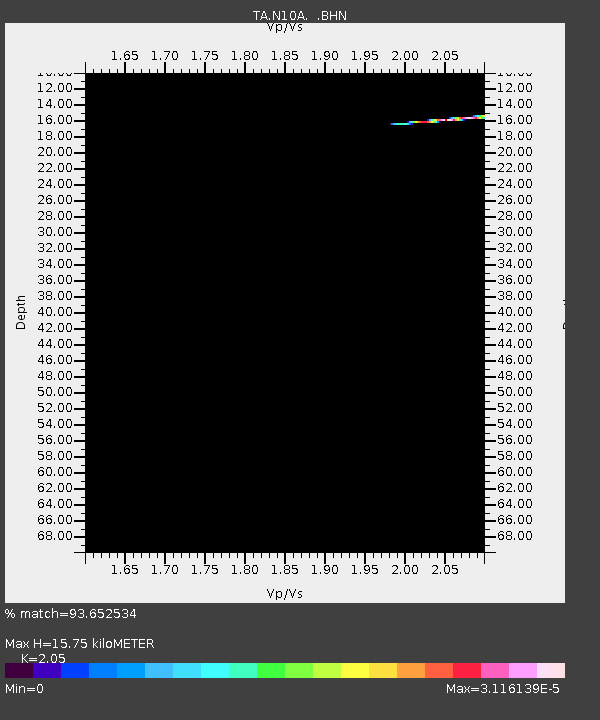
| Estimated Moho Depth: |
15.75 km |
| Estimated Crust Vp/Vs: |
2.05 |
| Assumed Crust Vp: |
6.276 km/s |
| Estimated Crust Vs: |
3.061 km/s |
| Estimated Crust Poisson's Ratio: |
0.34 |
|
| Radial Match: |
93.652534 % |
| Radial Bump: |
110 |
| Transverse Match: |
99.71761 % |
| Transverse Bump: |
32 |
| SOD ConfigId: |
2564 |
| Insert Time: |
2010-03-06 03:56:37.044 +0000 |
| GWidth: |
2.5 |
| Max Bumps: |
400 |
| Tol: |
0.001 |
|

Signal To Noise
| Channel | StoN | STA | LTA |
| TA:N10A: :BHN:20071008T17:20:57.074011Z | 0.5641123 | 1.2254469E-8 | 2.1723457E-8 |
| TA:N10A: :BHE:20071008T17:20:57.074011Z | 1.0463458 | 2.2994145E-8 | 2.1975664E-8 |
| TA:N10A: :BHZ:20071008T17:20:57.074011Z | 1.0557475 | 2.151878E-8 | 2.0382506E-8 |
| Arrivals |
| Ps | 2.7 SECOND |
| PpPs | 7.4 SECOND |
| PsPs/PpSs | 10 SECOND |


