You are here: Home > Network List > TA - USArray Transportable Network (new EarthScope stations) Stations List
> Station N10A Dunphy, NV, USA > Earthquake Result Viewer
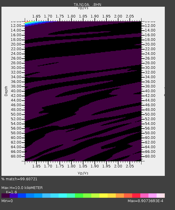
N10A Dunphy, NV, USA - Earthquake Result Viewer
| Earthquake location: |
South Of Mariana Islands |
| Earthquake latitude/longitude: |
10.5/145.7 |
| Earthquake time(UTC): |
2007/09/30 (273) 02:08:30 GMT |
| Earthquake Depth: |
14 km |
| Earthquake Magnitude: |
6.4 MB, 7.1 MS, 6.9 MW, 6.9 MW |
| Earthquake Catalog/Contributor: |
WHDF/NEIC |
|
| Network: |
TA USArray Transportable Network (new EarthScope stations) |
| Station: |
N10A Dunphy, NV, USA |
| Lat/Lon: |
40.72 N/116.51 W |
| Elevation: |
1392 m |
|
| Distance: |
89.1 deg |
| Az: |
48.868 deg |
| Baz: |
282.915 deg |
| Ray Param: |
0.04210275 |
| Estimated Moho Depth: |
10.0 km |
| Estimated Crust Vp/Vs: |
1.60 |
| Assumed Crust Vp: |
6.276 km/s |
| Estimated Crust Vs: |
3.922 km/s |
| Estimated Crust Poisson's Ratio: |
0.18 |
|
| Radial Match: |
99.68721 % |
| Radial Bump: |
25 |
| Transverse Match: |
99.7718 % |
| Transverse Bump: |
24 |
| SOD ConfigId: |
2564 |
| Insert Time: |
2010-03-06 03:56:45.568 +0000 |
| GWidth: |
2.5 |
| Max Bumps: |
400 |
| Tol: |
0.001 |
|

Signal To Noise
| Channel | StoN | STA | LTA |
| TA:N10A: :BHN:20070930T02:20:53.250017Z | 0.83996415 | 1.4469363E-8 | 1.7226167E-8 |
| TA:N10A: :BHE:20070930T02:20:53.250017Z | 1.4635928 | 2.4614046E-8 | 1.6817552E-8 |
| TA:N10A: :BHZ:20070930T02:20:53.250017Z | 0.74655455 | 1.5778244E-8 | 2.113475E-8 |
| Arrivals |
| Ps | 1.0 SECOND |
| PpPs | 4.1 SECOND |
| PsPs/PpSs | 5.0 SECOND |


